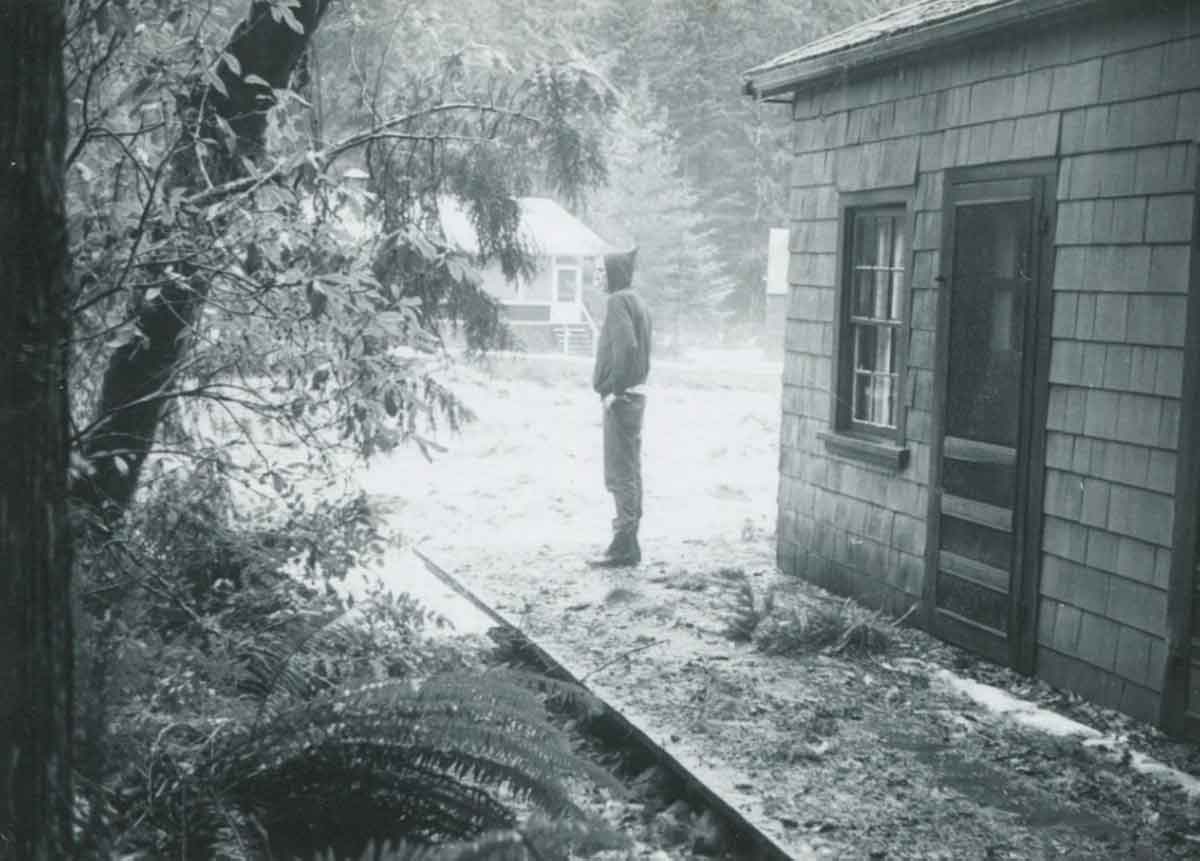
The Modern Barlow Trail Road

The Modern Barlow Trail Road

The Historic Paths of Barlow Trail Road and Lolo Pass Road

Have you ever driven along Barlow Trail Road or Lolo Pass Road and wondered about their origins? These quiet, winding roads are more than just modern routes—they are living pieces of history.

Long before cars or bicycles rolled over them, these paths were game trails and footpaths used by the region’s first inhabitants. Later, Oregon Trail pioneers relied on them as lifelines to complete their westward journey. Over time, they evolved into crucial connections for local residents and the modern communities we know today.

  and wondered about their origins? These quiet, winding roads are more than just modern routes—they are living pieces of history.

From Wagon Wheels to Hackett Road

In the mid-1800s, the original Barlow Trail served as a rough but vital route for settlers completing the Oregon Trail. As pioneers descended from Mount Hood, they followed the north side of the Zigzag River until they reached the Sandy River. At the big bend of the Sandy, they crossed over a log bridge built by settlers.

Later, the trail shifted to the south side of the Sandy River, leaving behind remnants of the earlier path. As a result, settlers repurposed parts of the old trail into local roads, including Hackett Road. This road, named after early settlers in the area, still carries their legacy in the name of nearby Hackett Creek.

The McIntyre Bridge: A Critical Connection

By 1910, settlers struggled to access the road on the north side of the Sandy River. Early bridges were unstable and often washed away, making travel difficult. That year, J.T. McIntyre, an early settler in Brightwood, took action. He built a sturdy bridge over the Sandy River, providing reliable access to the road on the north side.

This new bridge transformed travel in the area. Residents could now cross the river safely, and it became a key link for the growing community. Without McIntyre’s efforts, settlers on the north side would have remained isolated from the developing Mount Hood automobile road nearby. Consequently, his work played a crucial role in connecting these remote settlements.

  and wondered about their origins? These quiet, winding roads are more than just modern routes—they are living pieces of history.

The Road to The Truman Farm

Around the same time, Ezra and Eliza Truman homesteaded on the north side of the Sandy River, near Zigzag Ridge. Ezra, a mountain guide and farmer, relied on the newly connected road to reach his homestead. He used it to deliver milk and produce to his neighbors.

Over time, this route became known as Truman Road, named after the family who lived at its farthest end. Even after Ezra’s death in 1917, the road remained essential. It provided access to settler homes, cabins, and lodges, supporting the early tourism industry that grew alongside the increase in automobile travel to Mount Hood. Because of this, the area became a gateway for visitors exploring the region.

  and wondered about their origins? These quiet, winding roads are more than just modern routes—they are living pieces of history.

DeVeny Road: A Valuable Connection

In the early 1900s, Dr. William DeVeny, a Zigzag cabin owner and civic leader from Montavilla (now part of Portland), saw the need for better road access. With support from the Mount Hood Improvement Association and local government funding, he led the construction of DeVeny Road.

The new road linked the Mount Hood automobile road on the south side of the Sandy River to the east end of Truman Road on the north side. By 1913, the project was complete. Bridges were built over Bear Creek, the Zigzag River, and the Sandy River, creating a vital route for settlers, forest rangers, and early visitors to the Mount Hood wilderness. As a result, travel between the two sides of the Sandy River became much easier, further opening the area to development.

  and wondered about their origins? These quiet, winding roads are more than just modern routes—they are living pieces of history.

A Modern Legacy

As time passed, these roads continued to serve local communities while adapting to modern needs. In 1979, the Clackamas County Historical Society honored the pioneers by renaming Truman Road to Barlow Trail Road. This change recognized the historical importance of the original Barlow Trail.

Meanwhile, DeVeny Road became part of Lolo Pass Road, and its original name faded from memory. Yet, the routes themselves remain a testament to those who built them. Although the names have changed, their significance has not been forgotten.

Roads Worth Remembering

Today, whether you’re coming home, heading out, or simply enjoying a scenic drive, you are traveling through history. These roads are more than just asphalt and gravel—they are stories of resilience, determination, and community.

So, next time you find yourself driving down Barlow Trail Road or Lolo Pass Road, take a moment to appreciate the history beneath your wheels. After all, you are following in the footsteps and wagon tracks of those who came before us

  and wondered about their origins? These quiet, winding roads are more than just modern routes—they are living pieces of history.
The Mountain View Inn

The Mountain View Inn

A Lost Landmark of Government Camp

This historic photo captures the Mountain View Inn under heavy snow during the 1940s. Once a well-known hotel in Government Camp, Oregon, the inn played a key role in the town’s early ski culture. However, in 1955, a fire destroyed the building, leaving only memories behind.

A Pioneer Homestead Becomes a Hotel

The building originally belonged to Lena Little, wife of Francis C. Little, a pioneer homesteader. It first served as a private residence, but later, workers moved it to the north side of the main road in Government Camp. This relocation allowed it to become a hotel, serving visitors drawn to the growing ski scene.

Jack Rafferty’s Lodge and the War Years

After the move, Jack Rafferty leased the building and transformed it into a hotel and ski lodge. At first, he named it Rafferty’s or Rafferty’s Hut. Later, he purchased the property, establishing it as a local business.

During its early years, the hotel also went by the name Tyrolian Lodge, reflecting Government Camp’s Alpine influence. However, World War II forced the hotel to close, as tourism slowed and many businesses struggled.

A New Era: The Mountain View Inn

After the war, Harry Albright reopened the lodge and renamed it The Mountain View Inn. As tourism grew, Government Camp became a major skiing destination. With more visitors arriving, the inn became a popular stop for travelers heading to Mount Hood.

A Fiery End in 1955

In 1955, tragedy struck when the Mountain View Inn burned down. It once stood across the street from Daar’s Ski Shop, which later became Charlie’s Mountain View, a well-known landmark today.

Although the inn is gone, its history survives through photographs and stories. This image, showing the snow-covered hotel, serves as a reminder of Government Camp’s past and its early skiing culture.

The Mt Hood Skiway Tram
. The Mount Hood Aerial Transportation Company was formed with a plan to create an aerial tramway to Timberline Lodge on the south slope of Mount Hood from Government Camp, the gathering spot for every activity on The Mountain. It was to be called The Skiway

Tawney’s Mountain Home

Tawney’s Mountain Home

Tawney’s Mountain Home: A Forgotten Retreat in Welches, Oregon

A Hidden Gem in the Salmon River Valley

In the early days, the Welches Hotel wasn’t the only resort in the Salmon River Valley at the base of Mount Hood. About a mile past the Welches property, at the end of the road, sat Tawney’s Mountain Home. Surrounded by wilderness and nestled along the Salmon River, this hotel operated as a popular outdoor vacation spot from 1910 to 1945.

Hotel Maulding, welches Oregon

From Homestead to Hotel

The hotel was originally part of the Walkley family homestead, located south of Welches. While the Walkleys didn’t run a formal hotel, they did take in boarders. In 1906, John Maulding and his wife purchased the 100-acre property, which included the Walkley home. They remodeled and expanded the house, converting it into what became known as Maulding’s Hotel.

In 1909, Francis H. Tawney and his wife, Henriett, leased the property. A year later, they purchased it and began making improvements. However, in 1913, a fire destroyed a large portion of the original hotel. Undeterred, the Tawneys built a two-story addition, and by 1914, the new Tawney’s Hotel was welcoming guests once again.

Tawney's Hotel, Welches Oregon

A Grand Lodge with Rustic Charm

Tawney’s Hotel was a large two-story building with 15 guest rooms. Due to its popularity, tent cabins were added on the grounds to accommodate additional visitors.

Guests entered through a spacious living area featuring a large rock fireplace. A grand staircase led to the second floor, where the guest rooms were located. Connected to the living room, a huge dining room offered another stone fireplace and a long dining table for communal meals.

The hotel had only one indoor bathroom, located off the dining room. It included a commode and a bathtub, making reservations nearly necessary for guests who wanted to use it.

A Stay at Tawney’s Mountain Home

A week’s stay at the hotel cost $10, including meals. Mrs. Tawney, with help from her daughter-in-law, Emily, prepared food for guests. Meals were served family style, with platters of chicken, roast beef, and steak. Fresh bread, jams, canned foods, and homemade pies were always available. Mrs. Tawney also made large sugar cookies for the children, though adults often raided the cookie jar as well.

Keeping the kitchen stocked was no small task. Up to 150 guests might arrive for Sunday dinner, requiring a constant supply of food. Staples and canned goods were delivered weekly from Portland, while a butcher wagon from Sandy made daily summer deliveries, bringing cuts of beef and lamb packed in ice.

Tawney's Mountain Home, Welches Oregon

Living Off the Land

The Tawneys maintained their own livestock, including cows, pigs, and chickens. Guests could ride horses, and children often enjoyed rides on the two donkeys.

Mr. Tawney frequently took guests on wagon trips to Government Camp for huckleberry picking and picnic lunches. The property also included a large garden, an apple orchard, and wild berry patches for pie-making. Guests sometimes supplied trout from the Salmon River and local creeks, adding to the hotel’s menu.

In 1910, a group of three fishermen—B. Trenkman, C.J. Cook, and L. Therleson—ventured to Camp Creek for a fishing trip. They returned 1.5 hours later with 286 trout, making it one of the most legendary meals ever served at Tawney’s Mountain Home.

Tawney's Mountain Home, Welches Oregon

A Place for Summer Memories

Longtime Welches resident Nell Howe recalled that summer days at Tawney’s were filled with wonderful food and laughter. She said, “In the summertime, the tables in the dining room were full for every meal, and sometimes people were waiting their turn.”

Many guests fondly remembered their time at the lodge—swimming in the river, fishing, helping with chores, and enjoying the delicious home-cooked meals.

Tawney's Mountain Home, Welches Oregon

The End of an Era

By 1945, Tawney’s Mountain Home closed its doors, likely due to declining business and wartime shortages. The Tawneys, now older, stepped away from the demanding work of running the hotel.

Mr. Tawney passed away in 1947, and soon after, Mrs. Tawney moved to Portland to live with her daughter and son-in-law. She remained there until her passing in 1959.

A Fading Legacy

In the late 1950s, the abandoned lodge collapsed under the weight of a heavy snowstorm. A new owner later purchased the land and demolished the remains, leaving only the two original stone fireplaces standing.

Today, these fireplaces serve as the last visible reminders of Tawney’s Mountain Home—a once-thriving piece of Welches, Oregon’s history

Oregon pioneer history
Oregon pioneer history (1806–1890) is the period in the history of Oregon Country and Oregon Territory, in the present day state of Oregon and Northwestern

The Lil Toot Drive-In

The Lil Toot Drive-In

Wimpy’s Lil Toot Drive-In: A Lost Piece of Kelso, Oregon’s History

A Once-Popular Stop on the Mount Hood Highway

During the time when Orient Drive served as the main highway to Mount Hood, Clarence “Wimpy” Eri operated Wimpy’s Lil Toot Drive-In in Kelso, Oregon. The small drive-in, located across from the Kelso Store, became a popular stop for travelers heading to the mountain. Locals also frequented the spot, enjoying a quick meal and friendly service.

For years, the old highway route directed steady traffic through Kelso, keeping businesses like Wimpy’s thriving. The drive-in benefited from visitors who wanted a convenient place to grab food before continuing their journey. However, the construction of modern Highway 26 in the mid-1960s redirected traffic away from the town. With fewer customers, many small businesses, including Wimpy’s Lil Toot Drive-In, struggled to survive and eventually closed.

A Personal Connection to Wimpy’s Lil Toot

Kelso, Oregon, sits just west of Sandy, between Sandy and Boring. While many remember Wimpy’s Lil Toot Drive-In as a favorite roadside stop, others have a more personal connection to it.

One local recalls eating there many times as a young boy, as Clarence “Wimpy” Eri was a relative. The drive-in stood at the west side intersection of Kelso Road and Orient Drive, directly across from the Kelso Store. Families and travelers enjoyed the convenience of a small-town diner along what was once the primary route to Mount Hood.

A Lost Landmark of the Past

Although Wimpy’s Lil Toot Drive-In no longer stands, its memory remains part of Kelso’s history. The intersection of Kelso Road and Orient Drive, where it once stood, still echoes the past, reminding us of a time when small roadside diners thrived along the highway to Mount Hood.

This small, family-run business was one of many that once lined the old highway, catering to travelers who needed a break before heading further up the mountain. Today, while the landscape has changed, memories of places like Wimpy’s Lil Toot Drive-In live on through stories and those who remember stopping there for a meal.

Wimpy’s Lil Toot Drive-In: A Lost Piece of Kelso, Oregon’s History

Adolf Aschoff Marmot, Oregon

Adolf Aschoff Marmot, Oregon

Adolf Aschoff and Marmot, Oregon’s History

Marmot, Oregon: A Place More Than a Town

Marmot, Oregon, is a place more than it is a town. It is located along the last stretch of the Oregon Trail, the old plank-covered Barlow Road. Between 1883 and 1930, it was a destination for many people who came to experience the great outdoors and to launch their adventures on Mount Hood.

Located in the forested foothills on the west side of Mount Hood, about six miles east of the town of Sandy, Marmot is situated on a ridge with the Sandy River to the south and the Little Sandy River and Bull Run to the north. It was a wilderness when Marmot was established.

Dora and Adolf Aschoff Marmot Oregon

The Man Behind Marmot: Adolf Aschoff

The story of Marmot is less about a town or a place than it is about a man. Marmot’s pioneer and developer of the town’s commercial ventures, such as its store, hotel, stables, and museum, was Johann Adolf (Adolph) Aschoff. There were no other businesses there.

Aschoff was even Marmot’s postmaster when the post office was established in 1890, where he kept meticulous records in perfect penmanship. A German immigrant, he cemented his name into the fabric and history of Mount Hood and the south side towns between Sandy and Government Camp and, indeed, the whole Mount Hood National Forest.

Adolf Aschoff Marmot Oregon

From Germany to America

Adolf Aschoff was born in Celle, Hanover, Germany, on May 21, 1849. He was the son of a shoe manufacturer who was said to have descended from Russian royalty. Although he was educated for the clergy, his love for the outdoors led him down a different path.

His father wanted his children to be educated and cultured and not have to work in the factories as he had. Adolf’s education covered language, history, theology, art, music, and physical sciences. At sixteen, he worked with the Royal Forester—an experience that would serve him well throughout his life. He was also a talented musician, artist, storyteller, and one of Mount Hood’s earliest photographers.

Aschoff's Mountain Home
Aschoff’s Mountain Home
Aschoff's Mountain Home
Aschoff’s Mountain Home

Escape from Germany: Political Exile

In 1866, at the age of 17, Adolf organized a club of enthusiastic young men called the “Maybugs.” Their activities varied from studying to fun-making and, perhaps, a little political activism. However, they soon found themselves in trouble with Prussian officers during the Austro-Prussian War.

Although Hanover tried to remain neutral, in June of 1866, Germany mobilized troops against Prussia, leading to Hanover’s dissolution and annexation by Prussia. That summer, 17,000 Prussian soldiers crossed the Hanover boundary. Adolf and his Maybugs taunted the invading soldiers and plastered anti-Prussian posters around town, making him unpopular with the Prussians.

One night, after an altercation where several Prussian officers were knocked down, Adolf was forced to flee. He later claimed that he escaped to a lake, where he stayed submerged—except for his face—for an entire day. Eventually, he found refuge with a female benefactor, rumored to be Princess Fredericka, who helped him escape. He made his way to Austria, then to France, and later to England, where a forged passport allowed him passage to America as a political exile.

Bachelor Cabin - Aschoff's Mountain Home
Bachelor Cabin – Aschoff’s Mountain Home
Aschoff's Mountain Home
Aschoff’s Mountain Home

Life in America: Kansas and the Journey West

Adolf arrived in New York in November 1869 aboard the steamer Nebraska. He first worked as a woodcarver and engraver, but New York was too crowded for him. He moved to New Jersey, then Illinois, and finally to Kansas in 1871, where he and his brother Ernest homesteaded.

In 1872, Adolf married Dorotea “Dora” Gein in Rush County, Kansas. Dora was born in Germany on November 21, 1853, and had immigrated to America with her parents when she was 14. They started a farm in Kansas, where their first four children were born.

Adolf loved telling stories about his time in Kansas. He claimed to have met Calamity Jane and was hired by Buffalo Bill Cody to hunt buffalo for the railroads.

While in Kansas, he watched wagon trains pass by on their way to Oregon. In 1882, he and Dora decided to follow them. They left their homestead and moved to Portland, Oregon, where they lived near Mt. Tabor and sold vegetables.

Adolf was described as looking like a nobleman, with a trim goatee, elegant manners, and a strong German accent. His talent for storytelling and artistic and musical abilities made it easy for him to gather influential friends in the city. These connections later helped him develop his resort in Marmot.

Aschoff's Mountain Home
Aschoff’s Mountain Home
Aschoff's Mountain Home
Prize Horse at Aschoff’s Mountain Home

Founding Marmot, Oregon

In the spring of 1883, Adolf and Dora moved to Marmot, purchasing 240 acres along the last section of the Oregon Trail for $900.

Adolf never intended to run a resort, but his Portland friends encouraged him to. He built guest cabins, entertaining boarders for 50 cents per day or $3 per week. Business grew quickly. By 1902, Aschoff’s Mountain Home had expanded to 23 rooms, featuring wraparound balconies, a dining hall for 100 guests, and comfortable lodging.

Aschoff's Mountain Home
Prize horse at Aschoff’s Mountain Home
Aschoff's Mountain Home
A Horse and Child at Aschoff’s Mountain Home

The Naming of Marmot

In 1890, Adolf established the post office and named the area “Marmot.” Interestingly, he later discovered that the burrows he thought were made by marmots actually belonged to mountain beavers, but the name remained.

The Barlow Road, Marmot Oregon

A Guide and Forest Supervisor

On May 19, 1897, Adolf was appointed the first Forest Ranger for the Cascade Range Forest Reserve (which later became the Mount Hood National Forest). He blazed the Skyline Trail between Mount Hood and Mount Jefferson. However, bureaucratic conflicts led him to resign in 1906.

Aschoff's Mountain Home
Livestock at Aschoff’s Mountain Home
Aschoff's Mountain Home
The Barlow Road at Aschoff’s Mountain Home

Tragedy and Decline

In 1914, tragedy struck. Adolf and Dora’s youngest son, Gustav, drowned in the Sandy River. Just weeks later, their oldest daughter, Mary, died after a long illness.

Four years later, Dora also passed away. With Dora gone, the children growing older, and the new Mount Hood Loop Highway bypassing Marmot, the resort began to decline. Adolf remained there until 1929, when he sold everything to Percy Shelley.

Adolf was heartbroken, saying, “I cannot tell you how I feel giving up my place. My nine children grew up here, and I have gone through all kinds of hardships, but only God and I know how much I have loved it here.”

On May 16, 1930, Adolf Aschoff passed away in Portland.

Mazama's at Marmot Oregon
Mazama’s at Marmot Oregon
Mazama's at Marmot Oregon
Mazama’s at Marmot Oregon

The End of an Era

On July 4, 1931, Aschoff’s Mountain Home burned to the ground. The Shelley family lost everything. The remaining buildings quickly fell into disrepair.

Today, little remains of Marmot, yet those who pass through can still imagine what it must have been like at its peak, and why Adolf Aschoff loved it so deeply.


Source Information:
Photos from the Gary Randall collection
Information Bill White, Brightwood, Oregon
Sandy Pioneers, Early Settlers and Barlow Road Days – Sandy Historical Society
Jack Grauer – The Illustrated History of Mount Hood
Various newspaper articles from the period

Discover More Mount Hood History

If you love learning about Oregon’s past, check out more stories at MountHoodHistory.com.

Do you have memories or stories about Adolf Aschoff or Marmot Oregon? Share them in the comments below!

Aschoff's Mountain Home
Juicy and children at Aschoff’s Mountain Home
Aschoff's Mountain Home
Aschoff’s Mountain Home
Adolf Aschoff Marmot, Oregon
Aschoff's Mountain Home
Fishing on the Sandy River Aschoff’s Mountain Home
Marmot, Oregon
Marmot is an unincorporated community in Clackamas County, Oregon, United States located in the Mount Hood Corridor. It is within the boundaries of the

Adolph Aschoff
of Oregon in the late 19th century. He established the community of Marmot, Oregon in the western foothills of Mount Hood in the late 19th century. Most

Mount Hood Highway at Alder Creek 1939

Mount Hood Highway at Alder Creek 1939

Alder Creek is a little town half way between Sandy and Welches Oregon on today’s Highway 26.

The Ivy Bear at Alder Creek
Feb 15, 2017 If anyone can ID the folks in the photo please contact me. Thanks you. The Ivy Bear at Alder Creek.

Brightwood Museum and Novelty Shop: Mt Hood Loop History

Brightwood Museum and Novelty Shop: Mt Hood Loop History

A Piece of Brightwood History

The Brightwood Museum and Novelty Shop—known to many locals as the Snake Pit—was once a popular roadside stop along the old highway to Mount Hood. Located at the intersection of Bridge Street and Brightwood Loop Road, it sits today in quiet decay near the Brightwood Store. But once, this log cabin-style building drew the attention of curious travelers and vacationing families.

Built by Henry Steiner, Master Cabin Builder

This unique structure holds special historical value because it was the final log building constructed by the legendary Mount Hood craftsman Henry Steiner. Best known for his iconic cabins and lodges across the region, Steiner built this structure specifically as a souvenir shop for tourists passing through Brightwood on their way to the mountain. Over the years, the building also served as a church, a private residence, and even briefly operated as a reptile garden.

The Road to Mount Hood: Slower Days, Quirky Stops

Before Highway 26 was widened and straightened into the fast-moving route it is today, a trip to Mount Hood was a leisurely journey. Especially after World War II, families packed their cars and hit the road in search of fresh air, fishing, and mountain recreation. Roadside attractions—often referred to as “tourist traps”—were part of the charm of the drive.

In addition to the Brightwood Museum and Novelty Shop, the area boasted other quirky destinations like the Swiss Gardens and the Mt. Hood Indian Pageant. These attractions helped define the postwar tourist era on the mountain’s south side.

A Local Landmark in Decline

Although time has taken its toll, the building still stands as a reminder of the golden age of roadside tourism. Sadly, it’s now deteriorating and largely forgotten. But for those who remember its heyday—or discover its story today—it remains a cultural landmark worth preserving in memory, if not in restoration.

If you’re driving through Brightwood, take a moment to stop by the parking lot of the Brightwood Store. You’ll find the old log structure still standing, weathered but resolute, whispering stories of a different time in Mount Hood’s history.

Rhododendron Oregon Centennial and History

Rhododendron Oregon Centennial and History

100 Years of Rhododendron Oregon and Mount Hood Tourism

I produced a video to commemorate the 100th anniversary of the little Mount Hood village of Rhododendron Oregon. It’s a collection that consists of photos that I’ve collected through the years and have added to my collection. There are a couple that are in the video that are copies of photos from the Welch Family as well as the family of Dr Ivan Wooley.

Rhododendron, Oregon | Things to do, hotels, & attractions
Located along the Mt. Hood Scenic Byway on a 19th-century pioneer wagon route, Rhododendron nestles into the western flank of the craggy peak. The terrain.

Uncle Sam Welch’s Ranch in Welches Oregon

Uncle Sam Welch’s Ranch in Welches Oregon

From Homestead to Tourist Destination

The Beginnings of Welches

The history of the Welch’s Ranch in Welches Oregon begins in 1882. Before Welches became a popular destination, it was simply a family homestead ranch. Samuel Welch, an emigrant from Virginia, settled in the valley that year. Later, his son William “Billy” Welch and Edward Kopper, Billy’s first wife’s father, also homesteaded in the valley in 1889.

Establishing the Welch Ranch

Samuel and Billy Welch homesteaded adjoining 160-acre sections of the Salmon River Valley, located on the southwestern foothills of Mount Hood. Samuel’s homestead deed, signed by President Benjamin Harrison, was recorded in the Clackamas County Courthouse in 1893. Similarly, Billy’s deed, signed by President William McKinley, was recorded in 1898.

Over time, they expanded their holdings, acquiring nearly 1,000 acres that stretched from Walkley’s homestead in the south to “Dutch Fred’s” homestead in the north (near present-day Fairway Avenue). Their land also extended up the slopes of Hunchback Mountain to the east and Huckleberry Mountain to the west.

A Thriving Ranch and Early Tourism

The Welch Ranch was a fully operational farm with pastures, barns, and corrals for livestock, including dairy cows, beef cattle, sheep, and pigs. In addition, the family maintained an apple orchard, a large vegetable garden, and had access to abundant fish in the river and wildlife in the surrounding hills. A blacksmith shop and stables further supported the ranch operations.

As travel increased, the ranch became a stop for stagecoaches and later, motorized coaches en route to Mount Hood. Eventually, summer tourists began camping in the valley, taking advantage of its natural beauty.  

Transition to a Resort

After Samuel’s death in 1889, Billy took over the ranch. Sadly, his first wife, Mamie Kopper Welch, passed away in 1902. By 1905, Clinton Kern and a Mr. Wren leased the property and opened a hotel resort, operating it until 1909. As part of the resort’s development, a large dining hall was built near the Salmon River to accommodate guests.

To replace the old dance hall, Billy expanded his store, adding a pool room and a second-story dance hall. Notably, the hall featured an east-facing balcony where dancers could cool off while enjoying views of Hunchback Mountain.

Community and Entertainment

In 1911, Billy married Jennie Faubion. Together, they managed the resort, store, post office, and dance hall. Meanwhile, the Welches Post Office had been established in 1905, with Billy serving as postmaster until 1940. Afterward, Jennie continued in the role until her retirement in 1960. Eventually, the post office moved to Wemme before returning to Welches.

The local community often gathered for bonfires, taffy pulls, and marshmallow roasts. Children collected wood for towering bonfires while families sang folk songs like “Ninety-Nine Blue Bottles.” Moreover, talented storytellers entertained crowds late into the night.

Saturday night dances were a highlight, drawing nearly everyone in town. Parents brought blankets for their children, who slept in the hall’s corners while lively fiddle music filled the air. Typically, Billy Welch and other local musicians played old-time tunes as dancers whirled through two-steps, schottisches, and waltzes.

Growth of Tourism

By 1910, Welches had become a sought-after summer destination. In addition to the Welches Hotel, nearby lodges such as Tawney’s Mountain Home, Arrah Wanna Lodge, and the Rhododendron Inn catered to vacationers. To meet increasing demand, Billy expanded the ranch into a full-fledged outdoor resort, adding tent cabins and campgrounds along the Salmon River.

As interest in the area grew, Billy allowed repeat visitors to camp on designated plots. Eventually, he subdivided and sold land for vacation cabins. The Kaderly family built the first vacation cabin south of the hotel by relocating Samuel Welch’s original homestead cabin.

Development of Local Businesses

Around 1885, Samuel Welch sold five acres to John and Mary Roberts of Gresham. Their son, Ed Roberts, worked in the Welches Store before marrying Dora Owens in 1903. Later, in 1913, Ed opened Roberts Country Store near the Welches Hotel, expanding the town’s commercial offerings.

The Welches Golf Course

In 1928, Ralph Waale leased Welch’s pasture and built a nine-hole golf course. He operated it until 1939, when ownership returned to the Welches. Shortly after, Billy and Jennie continued running the course until Billy’s passing in 1942. Over time, it changed hands multiple times before being sold to Eugene Bowman.

The Lasting Legacy of the Welch Ranch’s Ranch in Welches Oregon

Billy Welch played a pivotal role in shaping Welches into a tourist destination. His foresight in converting the ranch into a resort laid the foundation for the town’s growth. Though the original homestead is gone, the legacy of the Welch family endures in the community that still bears their name.

The Welch’s Ranch in Welches Oregon.

CLICK HERE to read more about the development of the Mt Hood Golf Course, Rippling River and the Resort on The Mountain.

Mrs Pierce of Welches Killed a Bear With a Hoe
Mrs Pierce of Welches Killed a Bear With a Hoe – I have spent a lot of time talking with old timers and family

Mt Hood Indian Pageant

Mt Hood Indian Pageant

A lot has come and gone along the old Mt Hood Loop Highway, the name given for the route that started in Portland and followed old Highway 30 along the Historic Columbia River Highway to Hood River then along the present Highway 35 south from Hood River to Government Camp and the back to Portland via Highway 26, the route of the original Barlow Trail and the Mt Hood Highway. Of course it could be travelled in either direction, but either way the route would take one completely around Mount Hood. It’s still a very popular “Sunday drive” for those wanting to get away and see some scenery.

Things have changed through the years – Cars are faster and roads are better. Today one can take the drive and only stop for a quick lunch before they arrive back at home again all within a day, but there once was a time when folks would take the trip on the old Mt hood Loop and take a week long vacation to do it. During those times there were many more stops to be had along the way that were tourist draws such as restaurants, lodges, roadhouses and recreational activities. There were even more camping options back then.

Much of this activity took place prior to World War II but the boom happened soon after the end of the war. Post World War II saw more people able to afford cars and free time and the roads and automobiles were improved. At that time a lot of soldiers were back home from the war and were looking to start a future for them and their families. Some built attractions along the old Loop Highway to try to pull these tourists in and extract some of their money in exchange for entertainment, lodging or meals. One such short lived attraction that sprung up was the Mt Hood Indian Pageant in Brightwood about 15 miles east of Sandy Oregon.

In 1947 one such soldier named Max Gilroy and his wife Virginia had the idea to set up a fort and to recruit Indians to come and setup an encampment and show tourists the ways of the Native American. Max and Virginia were very much interested in Native American history and tradition.

He and his wife Virginia, with help from friends, including Warm Springs Indians that they knew, put all that they had into building the Mt Hood Indian Pageant that included a post constructed Fort Barlow. They advertised “Pageant Performances Daily” and to “Bring your camera”. The fort touted the sale of Indian curios a pioneer restaurant, saddle horse rides and playground and picnic grounds.

There was a grand performance daily where one could observe the Warm Springs Indians as they presented “a view of their aboriginal life prior to the coming of the white man”. During the performance an “Indian brave” would come back to camp, wounded by an enemy tribe spurring the encampment to prepare for war. In time the victorious warrior would “return to camp with prisoner” and a “scalp dance” ensued.

Once peace was restored to the encampment the Indian girls would would dance, a young couple would marry in a ceremony and the chiefs would smoke a peace pipe. Then “with the coming of the white man, the Indians move west in their tragic quest for the freedom they loved so well”. Tourists would watch as if attending a play.

I can’t find evidence that the Mt Hood Indian Pageant lasted more than a season, maybe two. No evidence of the old fort exists today. The location is nothing more than a level piece of land that now contains more modern homes along what is now Brightwood Loop Road, just west of the town of Welches.

If not for a few photographs and postcards, and an advertising flyer or two, this place would be forgotten.