Mount Hood Auto Stages: From Rugged Roads to Modern Highways

Mount Hood Auto Stages: From Rugged Roads to Modern Highways

The Rise and Fall of Primitive Travel on the Old Barlow Road

The Early Days of the Mount Hood Auto Stages

In the early 20th century, long before travelers zipped up Highway 26 to the ski lifts and resorts of Mount Hood, the trip to the mountain was rugged and uncertain. The road, built on the bones of the old Barlow Trail, was steep, narrow, and either muddy or dusty depending on the season. For those without their own means of transportation—and even for those who did—reliable travel meant trusting the early Mount Hood auto stages and their legendary drivers who knew every twist, rut, and washout of the mountain road.

Olinger Stages to Mount Hood.
Olinger Stages to Mount Hood

The Route to the Mountain

Before the 1880s, travelers followed the original Barlow Trail, carved out by immigrant wagon trains in the 1840s to the 1860’s. This immigrant trail came from Central Oregon and passed over Mount Hood’s southern shoulder. The route took travelers through the area that we know today on the south side of Mount Hood. Coming down from the mountain the route followed the north side of the Zigzag River and then crossed the Sandy River to the north side and through what we now know as Marmot. This remained the primary route until settlement increased east of Sandy.

In the 1880s, a new south side road connected Sandy to Government Camp by following the south bank of the Sandy River. This alternative offered gentler grades, primitive but useful bridges creating more reliable access. Consequently, it soon became the main road to and from the mountain. Meanwhile, the Marmot Road continued as a scenic alternate, especially for travelers heading to Aschoff’s Mountain Home.

The primary route—used by both stagecoaches and auto stages—passed through Sandy, Cherryville, Brightwood, Welches, Zigzag, Rhododendron, and Government Camp. Notable stops included the Cherryville Hotel, Welch’s Hotel, Tawney’s and the Rhododendron Inn, and others.

Mount Hood Auto Stages - Rhododendron Inn
The Rhododendron Inn

The Stage Lines and Their Drivers

Initially, travelers relied on horse-drawn stages operated by local residents. Joe Meinig and Walter Ziegler were among the best-known drivers in those early days. However, as the road improved and mountain tourism grew, motorized stages entered the picture.

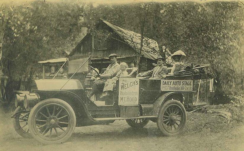
By the 1910s, auto stages had largely replaced horse-drawn wagons. Bob Elliott, a Sandy garage owner, led the way with one of the first regular lines to Government Camp. His rugged fleet of Pierce-Arrows, Cadillacs, and White touring cars came equipped with chains, spare tires, and tools for inevitable roadside repairs.

One of the most prominent operations was Reliance Mount Hood Stages. They offered daily trips from Portland’s eastside waterfront and coordinated with nearly every lodging stop along the route. Their Touring Cars became a familiar sight climbing the dusty grades to Rhododendron and beyond.

Among the legendary drivers was Dr. Ivan M. Wooley. His memoir, Off to Mt. Hood – An Auto Biography Of The Old Road, preserves vivid recollections of the people, places, and perils of early auto stage travel. His storytelling has given us one of the richest surviving records of this vanished era.

Ivan Woolley Stuck on the Road to Mount Hood

Hard Roads and Gritty Travel

Despite the switch from horses to horsepower, travel remained difficult. The roads were merely widened wagon paths. On steep hills like Laurel Hill and McIntyre Hill, passengers often had to walk. The latter, near Brightwood, posed such a challenge that hotelier John McIntyre charged motorists a fee to haul their cars up the grade with his horses. Eventually, widening the road, regrading the hills and decreasing the grades helped. Still, early autos struggled.

Drivers had to wear many hats: mechanic, navigator, and even peacemaker. They fixed broken axles, crossed flooded creeks, and comforted uneasy passengers. Some vehicles towed freight. Others had canvas tops for sun and rain. The trip could last all day, but for many, that was part of the fun.

Mount Hood Auto Stages
Broke down in Government Camp

Mountain Tourism and the Resorts That Made It Possible

The auto stages helped turn Mount Hood into a major Oregon destination. Easier access drew tourists eager to escape city heat or enjoy snowy slopes. Resorts like Welch’s Ranch, Arrah Wanna Lodge, Tawney’s Mountain Home, and the Rhododendron Inn thrived. They offered lodging, camping, hearty meals, hunting, fishing, hiking, dances and community bonfires. Most worked directly with stage lines, ensuring guests could be dropped off at their doorsteps. Back then, the journey, the lodging, and the scenery created a complete experience.

Reliance Auto Stages at Welches

The Automobile Takes Over

By the mid-1920s, personal automobiles had changed everything. Tourists no longer needed to reserve stage seats. They could drive, stop where they pleased, and enjoy more freedom. Ironically, the new Mount Hood Loop Highway—built to improve access—also ended the era of the auto stage. Independence had arrived.

Mount Hood Auto Stages
The Mount Hood Loop Highway at Alder Creek on The Road to Mount Hood

The End of the Line for The Mount Hood Auto Stages

In 1923, the Mount Hood Loop Highway was completed, dramatically altering travel to the mountain. With the addition of a road to Hood River on the east side, the full loop was in place.

As roads improved and cars became more dependable, scheduled auto stages became obsolete. Tourists drove themselves, and although the mountain resorts endured, the days of colorful drivers and mechanical struggles quietly faded away.

Reliance Auto Stages Advertisement

Love Mount Hood History?

Discover more local stories, rare photos, and forgotten places:

Follow the trails. Meet the people. Uncover the past.

Lolo Pass Ski Trip

Lolo Pass Ski Trip

A Classic Lolo Pass Ski Trip from 1955

Lolo Pass, located on the west side of Mount Hood, is a historic mountain route connecting Zigzag on the southwest side to the Hood River Valley on the north. The road runs between Mount Hood’s western slopes and the Bull Run watershed, the primary water source for Portland.

A Glimpse into the Past

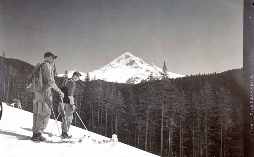
As a collector of old Mount Hood photographs, I recently came across a fascinating set of images from a Lolo Pass ski trip in 1955. These medium-format negatives, dated April 5, 1955, capture a group of skiers enjoying a perfect day in the snow.

The photos reveal a breathtakingly clear view of Mount Hood in the distance. The skiers appear well-prepared for their journey, and one detail stands out—they seem to have access to a gated road, an unusual privilege even at the time. One image even includes a sign marking the Bull Run Lake Trail, a landmark that helps confirm their location.

Lolo Pass Then and Now

While much of Lolo Pass Road remains accessible today, things have changed significantly. Since the passage of the Patriot Act, access to everything west of Lolo Pass Road leading to Bull Run Lake has been restricted. The area, once open to recreation, is now off-limits to protect Portland’s drinking water supply.

Despite these changes, many of the viewpoints captured in the 1955 photos remain unchanged. If you were to visit today, you could still recognize some of the same scenic overlooks, standing where these skiers once enjoyed their day in the snow nearly 70 years ago.

These photos serve as a rare and nostalgic window into a time when adventure on Lolo Pass was freer and less restricted—a reminder of Mount Hood’s enduring beauty and history.

Pacific Crest Trail
Springs Indian Reservation (10) Timberline Lodge Mount Hood Wilderness Lolo Pass Columbia River Gorge National Scenic Area (8) Mark O. Hatfield Wilderness

American – Swiss Model Garden at Brightwood, Oregon

American – Swiss Model Garden at Brightwood, Oregon

At one time there was the American – Swiss Model Garden Brightwood, Oregon.

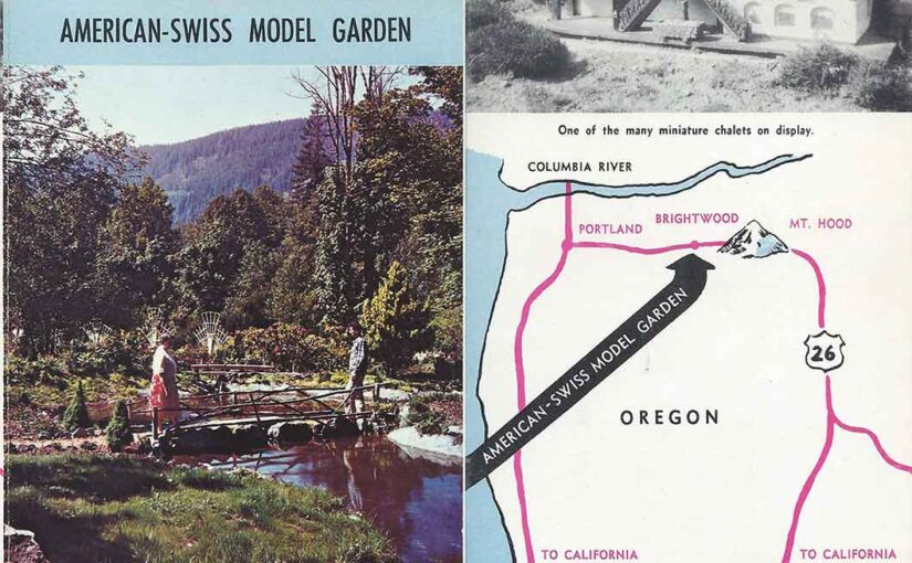
This is only one of many small businesses and tourist themed stopping spots along the highway to Mount Hood in the 1940-1960’s. This is an old flyer advertising the American – Swiss Model Garden at Brightwood, Oregon.

If anyone reading this can positively identify the location of this place I will revise this article and add that information. Thank you.

“Open from Dawn to Dusk. Open early April until the end of October. Bring you camera along.

Nowhere is there anything like it and this is certainly true for the American – Swiss Model Garden. It is a lovely combination of a lovely rock and flower garden, featuring small water-pools, rustic looking bridges, miniature waterfalls, as well as miniature Alpine houses and castles.  Through the greater part of the garden a miniature railroad is running, fascinating young and old. Three trains (freight, passenger, and express), all Swiss styled, alternate in running through the garden. A picturesque alpine village, miniature size, containing the railroad station, church, castle and a number of Swiss Alpine houses, amazes all visitors.

Flower lovers also will be thrilled by the variety of the many flower beds, just to mention the American and Swiss flags done in flowers. Beautiful hanging baskets add much to the beauty and atmosphere of this garden. Edelweiss and Alpenrosen are among the outstanding rock plants. Of special interest is the rose garden section, containing rose bushes, climbing roses, tree roses, and miniature roses.

The garden is placed in a natural setting and its atmosphere is very informal and relaxing. As you admire and enjoy it, music, mostly Swiss Alpine (accordian (sic) and yodeling), will accompany you.

A truly beautiful garden… a place worthwhile to visit.”

It’s certainly a shame that we no longer have such a simple culture to support such businesses as the American – Swiss Model Garden Brightwood, Oregon.

The Ivy Bear at Alder Creek

The Ivy Bear at Alder Creek

The Rise, Fall, and Revival of the Ivy Bear at Alder Creek: A Highway 26 Landmark 

For decades, travelers along U.S. Highway 26 in Oregon have been greeted by a unique roadside landmark: the towering Ivy Bear at Alder Creek. Covered in thick vines and steeped in local lore, this massive figure has become a beloved symbol of the Mount Hood area. Built as a tribute to a pet bear, it eventually collapsed, but thanks to a dedicated community, it rose again.

The Ivy Bear in 1959

The Man Behind the Ivy Bear at Alder Creek

The story of the Ivy Bear begins with Gerald Wear, a deaf craftsman, dog trainer, and builder who lived in Alder Creek. Wear was widely known for his ingenuity and deep love for animals. Alongside training German Shepherds, he also cared for a bear that lived in a roadside cage. As travelers passed along the two-lane highway, many stopped to watch the bear, which quickly became an unofficial mascot.

Gerald Wear the builder of the Ivy Bear

Eventually, the bear passed away. According to local accounts, it died after consuming too many candy bars, soda pop, and bottle caps handed out by curious onlookers. Heartbroken, Wear felt compelled to honor the animal. He decided to create a much larger tribute: a towering ivy-covered bear that would stand beside the road for all to see.

The bear at Alder Creek

Building the Largest Ivy Structure in the World 

In 1947, Wear began construction on what would become the Ivy Bear at Alder Creek. He built a wooden frame, wrapped it in chicken wire, and carefully planted ivy around the structure. Over the course of more than a year, the vines filled in, eventually covering the entire bear.

In the news

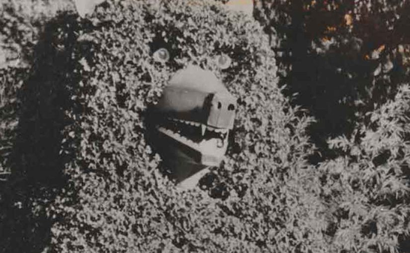
At the time, the figure was believed to be the largest ivy-covered structure in the world. Motorists quickly became accustomed to the sight of the massive bear keeping watch near the highway. To make the figure even more lifelike, Wear added a rear door and scaffolding inside that led up to the bear’s head. At night, he would climb inside and light its eyes with candles. Later, he upgraded them with old Volkswagen taillights.

The Ivy Bear showing the original eye which were replaced by Volkswagen taillights.

A Growing Landmark Along Highway 26

Over time, the Ivy Bear at Alder Creek became even more popular. In fact, it eventually became better known than the businesses located on the property. Mount Hood skiers adopted a tradition of saluting the bear for good luck, and children often lifted their feet as they passed by.

Meanwhile, Wear continued working on creative projects in Alder Creek. In addition to the bear, he built homes and decorative water wheels. Although Wear passed away in 1972, his most famous creation remained standing—a lasting testament to his creativity and love for the area.

Healthy Ivy on the bear.

The Fall of the Ivy Bear in June 1984

After nearly 40 years of standing tall, the Ivy Bear collapsed on June 18, 1984. A gentle breeze that evening was all it took to bring down the aging wooden structure. The bear toppled forward and landed on its tin snout.

Upon closer inspection, the cause became clear: the wooden beams at the base had rotted through. Without a strong foundation, the structure simply gave way. Although exterior damage was minimal, the bear could no longer stand upright.

The loss resonated with the community. Travelers slowed down, searching for the familiar landmark. Even the Portland Chamber of Commerce reached out to the property’s owners, eager to help restore the iconic roadside figure.

Largest Bear In The World

A Community Comes Together

Recognizing the Ivy Bear’s cultural value, local residents and organizations launched a campaign to bring it back. In 1987, Ron Rhoades, owner of the Ivy Bear Restaurant, partnered with Michael P. Jones of the Cascade Geographic Society and the Friends of the Ivy Bear to start a fundraiser.

By 1990, their efforts paid off. The community raised enough money to rebuild the Ivy Bear—this time using a steel frame designed to withstand time and weather. Thanks to their perseverance, the Ivy Bear stood once again.

The Ivy Bear in need of new ivy.

The Ivy Bear Returns to Alder Creek 

The bear’s revival brought renewed energy to the Mount Hood area. Locals and travelers alike celebrated the return of the iconic figure. Once more, the Ivy Bear stood proudly along Highway 26, welcoming visitors and honoring its unique history.

Today, the Ivy Bear remains a bit overgrown but continues to charm passersby. It stands not only as a tribute to Gerald Wear’s craftsmanship and compassion but also as a symbol of community pride. Next time you drive through Alder Creek, don’t forget to salute the bear—just like generations before you.

The Largest Bear in The World