Fires, Fear, and Fighting Back: The Week the Forest Burned Near Mt. Hood

The Forest Fires of October 13-17, 1952

A Dry Season Sparks Trouble

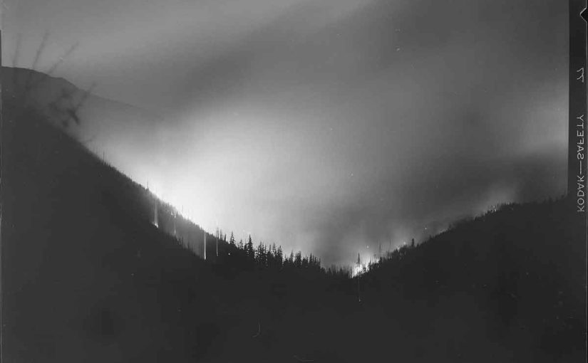
Late in the season, around midnight on October 13, 1952, trouble began in the dry forests surrounding Mt. Hood. Flames appeared south of the Mt. Hood Highway, just east of Rhododendron, near Yocum Falls. As the fire moved down through Laurel Canyon, it stretched toward Flag Mountain. Initially, officials suspected a tree had fallen on a power line, sparking the blaze. However, the Sandy Electric Company suggested that men violating the hunting ban may have started the fire instead of the 33,000-volt power line.

Mt Hood National Forest Fires of October 1952

Fires Spread Across the Region

Meanwhile, a second fire erupted when windblown embers ignited dry vegetation near Still Creek, along the north slope of Zigzag Canyon. As a result, flames threatened summer homes and caused landslides, sending large rocks tumbling toward the Zigzag River. Consequently, firefighters faced an increasingly dangerous situation.

By Tuesday, October 14, another fire had ignited. This time, flames burned up Henry Creek toward Devils Canyon near Rhododendron. Since dry east winds were blowing with typical intensity, they fanned the flames. Therefore, firefighters struggled to contain the rapidly spreading fires.

Mt Hood National Forest Fires of October 1952

Road Closures and Evacuations

Due to the growing danger, officials closed the Mt. Hood Highway. Roadblocks went up in Sandy and Bend, allowing only emergency vehicles and buses to pass. As a precaution, traffic had to be rerouted through the Columbia River Gorge or the North Santiam Highway. Firefighters hosed down wooden bridges along the highway while residents sprayed their roofs with water, trying to keep embers at bay. Understandably, people in Rhododendron prepared to evacuate if necessary. The county’s civil defense agency remained on high alert, ready to assist should homes become threatened.

Mt Hood National Forest Fires of October 1952

Arson Suspected in Brightwood

By Wednesday, October 15, conditions worsened. A third fire ignited near Brightwood around noon. Flames burned through thick ferns and second-growth timber. Unfortunately, local residents reported seeing two teenage boys speeding away in a blue coupe just before the fire started. Consequently, police issued an alert, but the suspects were never found.

Mt Hood National Forest Fires of October 1952

A Threat to Bull Run Watershed

By Thursday, October 16, tensions ran high. The Brightwood fire moved toward the Bull Run watershed, the primary water source for Portland. Since winds carried the flames up Boulder Creek, they brought them dangerously close to Bull Run. Meanwhile, in Rhododendron, a 120-man crew worked tirelessly to build a fire line around the Henry Creek blaze. More than 400 firefighters battled flames across the region. At the same time, at Zigzag Ranger Station, local women volunteered to prepare sandwiches, helping to sustain the exhausted fire crews.

Mt Hood National Forest Fires of October 1952

Firefighters Gain Control

Finally, on Friday, October 17, firefighters gained the upper hand. Crews, totaling 700 men, worked around the clock to contain the fires. By this point, the Brightwood blaze alone had consumed between 300 and 400 acres. In total, an estimated 1,200 acres burned before firefighters managed to control the destruction. Despite the progress, northeast winds and low humidity kept everyone on edge, hoping for much-needed rain.

Mt Hood National Forest Fires of October 1952

A Community United

In the aftermath, the fires left a lasting impact. However, they also demonstrated the strength of the community. Firefighters risked everything to contain the flames, while residents took action—hosing down homes, preparing food, and offering support. Although the forest would recover, the stories of that harrowing week of the Forest Fires of 1952 would endure for generations.

Mt Hood National Forest Fires of October 1952

Preserving the History

These photos are scanned from negatives in my personal collection, capturing the unforgettable events of that historic fire.

Mt Hood National Forest Fires of October 1952

The Modern Barlow Trail Road

The Historic Paths of Barlow Trail Road and Lolo Pass Road  

Have you ever driven along Barlow Trail Road or Lolo Pass Road and wondered where they came from? These quiet, winding roads are more than just roads we take to come and go—they’re living pieces of history.   

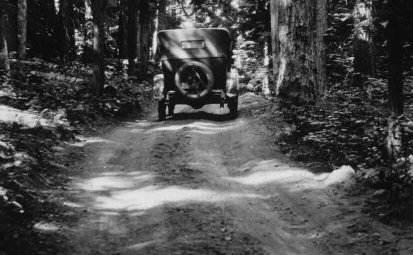
Long before cars or bicycles rolled over these paths, there were game trails and pathways used by the area’s first inhabitants. Later, they became lifelines for Oregon Trail pioneers. Over time, they evolved into crucial connections for residents and the modern communities we know today.   

From Wagon Wheels to Hackett Road  

Back in the mid-1800s, the original Barlow Trail was a rugged but vital route for settlers completing the Oregon Trail. As pioneers descended from Mount Hood, they followed the north side of the Zigzag River to its meeting point with the Sandy River. At the big bend of the Sandy, they crossed using a log bridge built by settlers.  

Later, the trail shifted to the south side of the Sandy River, leaving remnants of its earlier path behind. Eventually, parts of the old trail were reworked into rudimentary roads for local use, including one that became Hackett Road. Named after early settlers in the area, the memory of whom lives on in the name of nearby Hackett Creek.   

The McIntyre Bridge: A Critical Connection  

By 1910 access to the road on the north side of the Sandy River was a challenge for settlers. Simple, primitive, early bridges would come and go depending on the water levels of the Sandy River. In that year J.T. McIntyre, an early settler in the Brightwood area, built a sturdy bridge over the Sandy River at Brightwood, creating access to the road on the north side of the river.  

This new bridge not only facilitated travel for those living in the area but also laid the groundwork for the road’s later development and naming. Without McIntyre’s efforts, the settlers on the north side would have remained isolated from the growing Mt Hood automobile road nearby.  

The Road to The Truman Farm  

Around the time that the McIntyre Bridge was built, Ezra and Eliza Truman homesteaded on the north side of the Sandy River, near Zigzag Ridge. Ezra, a mountain guide and farmer, used the newly connected road to access their homestead and to deliver milk and produce to their neighbors.  

Over time, this road became known as Truman Road, named after the family who lived at the very end. The route remained essential even after Ezra’s death in 1917, as it provided critical access to settler’s homes, and cabins and lodges to service a newly forming tourism industry that would develop in the area with the increase of automobile traffic on the old automobile road to Mount Hood.  

DeVeny Road: A Valuable Connection  

In the early 20th century, Dr. William DeVeny, a local Zigzag cabin owner and civic leader from Montavilla, now a part of Portland, saw the need for further improvements to the local roads. With support from the Mount Hood Improvement Association, formed by DeVeny and other locals who would benefit from the new road, as well as local government funding, he spearheaded the construction of DeVeny Road linking the Mount Hood automobile road on the south side of the Sandy River to the east end of Truman Road on the north.  

By 1913, the project was complete. Bridges over Bear Creek, the Zigzag River, and the Sandy River were built. DeVeny Road became a vital road for settlers, forest rangers, and visitors exploring the Mount Hood wilderness.  

A Modern Legacy  

Time moved on, but these roads kept serving the community, adapting to new needs while preserving their historical roots. In 1979, the Clackamas County Historical Society renamed Truman Road to Barlow Trail Road, paying homage to the pioneers who forged the original trail. Meanwhile, DeVeny Road became part of what we now know as Lolo Pass Road and its original name faded from memory.  

Roads Worth Remembering  

Today, whether you’re coming home, heading out, visiting a neighbor, or simply enjoying a scenic drive, you’re traveling through history. These roads are more than asphalt and gravel—they’re stories of ancient times, courage, determination and, ultimately, community.  

So next time you’re driving down Barlow Trail Road or Lolo Pass Road, take a moment to appreciate the history beneath your wheels. You’re following in the footsteps—and wagon tracks—of those who came before us.  

The Brightwood Museum and Novelty Shop

The Brightwood Museum and Novelty Shop. Many locals who remember this place in its heyday still call this the Snake Pit. In its lifetime it was several things, including a church and a home. The building was constructed by renowned Mount Hood cabin builder Henry Steiner as a roadside tourist souvenir shop along the way to Mount Hood. This was his last log structure project. At one point it was even a reptile garden.

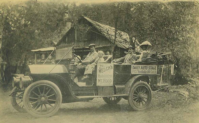
Back before cars were developed into the high speed vehicles of today, and Highway 26 was blasted into straight line four lane route that allowed everyone to move at speeds in excess of 55 miles per hour, a trip to Mount Hood was more of an easier pace. Post World War II was a time when families took to the highways on days off and vacations to camp and to recreate. The tourist industry was a big deal, with roadhouses and unique roadside attractions. Many people called these places “tourist traps”.

In our area here on the south side of Mount Hood there were several businesses that provided both lodging and meals. A couple of the tourist traps that were here, included this business, the Brightwood Museum and Novelty Shop, the Swiss Gardens and the Mt Hood Indian Pageant.
This old building is a cultural treasure to our area but sadly it’s falling into ruins. You can still see this old structure at the intersection of Bridge Street and Brightwood Loop Road in the parking lot of the Brightwood store.

American – Swiss Model Garden at Brightwood, Oregon

At one time there was the American – Swiss Model Garden Brightwood, Oregon.

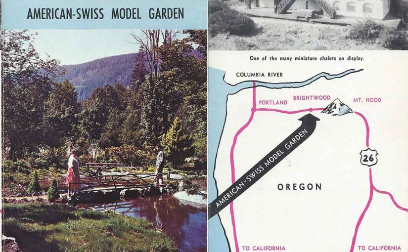
This is only one of many small businesses and tourist themed stopping spots along the highway to Mount Hood in the 1940-1960’s. This is an old flyer advertising the American – Swiss Model Garden at Brightwood, Oregon.

If anyone reading this can positively identify the location of this place I will revise this article and add that information. Thank you.

“Open from Dawn to Dusk. Open early April until the end of October. Bring you camera along.

Nowhere is there anything like it and this is certainly true for the American – Swiss Model Garden. It is a lovely combination of a lovely rock and flower garden, featuring small water-pools, rustic looking bridges, miniature waterfalls, as well as miniature Alpine houses and castles.  Through the greater part of the garden a miniature railroad is running, fascinating young and old. Three trains (freight, passenger, and express), all Swiss styled, alternate in running through the garden. A picturesque alpine village, miniature size, containing the railroad station, church, castle and a number of Swiss Alpine houses, amazes all visitors.

Flower lovers also will be thrilled by the variety of the many flower beds, just to mention the American and Swiss flags done in flowers. Beautiful hanging baskets add much to the beauty and atmosphere of this garden. Edelweiss and Alpenrosen are among the outstanding rock plants. Of special interest is the rose garden section, containing rose bushes, climbing roses, tree roses, and miniature roses.

The garden is placed in a natural setting and its atmosphere is very informal and relaxing. As you admire and enjoy it, music, mostly Swiss Alpine (accordian (sic) and yodeling), will accompany you.

A truly beautiful garden… a place worthwhile to visit.”

It’s certainly a shame that we no longer have such a simple culture to support such businesses as the American – Swiss Model Garden Brightwood, Oregon.

Villages of Mt Hood Post Offices

The Villages of Mt Hood Post Offices

What gives a town, or in this case a village, its identity? In most cases it’s the establishment of a post office. Many feel that the establishment of a post office is truly that which makes a settlement a town or a village. The case is no different here on The Mountain, as each of our villages have been identified in that very same way. That identity still exists in places that no longer have a post office, such as Zigzag, Wemme and Faubion.

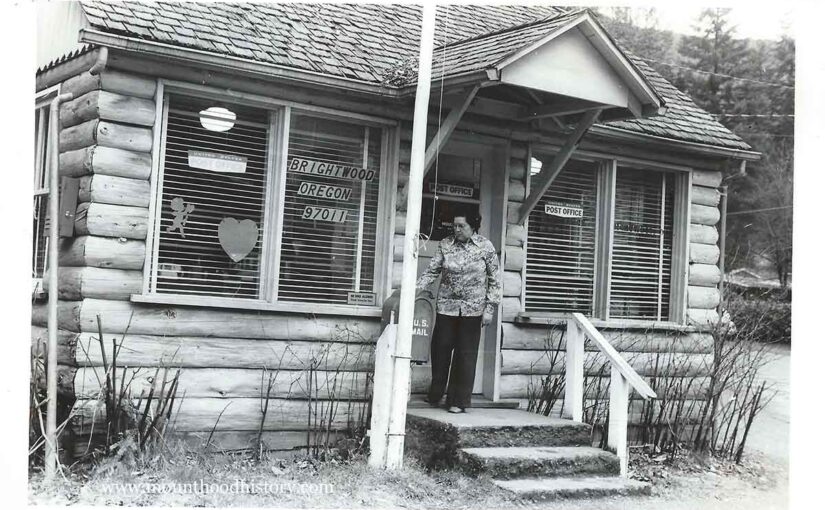
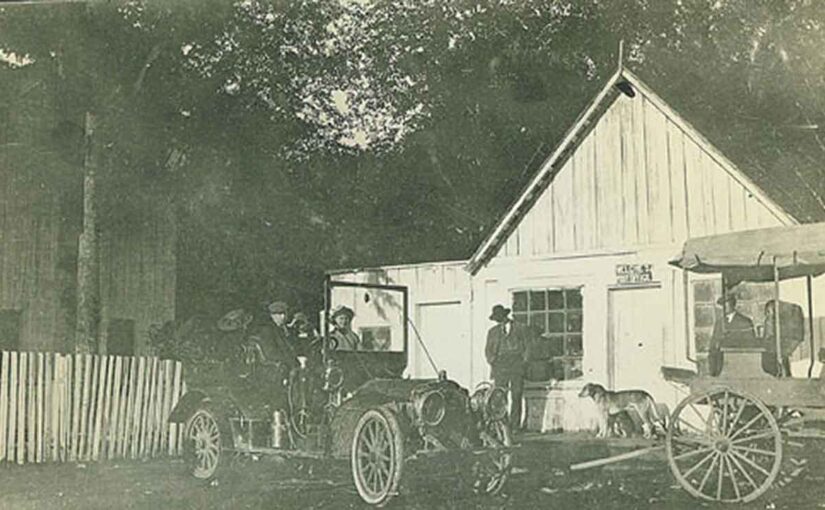
One might think that Welches, being the center of attention in our area, would have been the first post office to be established here, but it was actually the roots of the present day Brightwood post office that makes that claim. Samuel Welch, a local pioneer and Welches namesake’s first venture in the area was a hotel and general store in what was then called Salmon, Oregon, with a post office being established in 1891. His hotel was located near the present west end of Brightwood Loop near the Salmon River, and it wasn’t until 1910 that the name Brightwood was adopted. At that point in time it was located inside of McIntyre’s General Store near its present location. The Brightwood Post Office was discontinued in 1914 but reestablished in 1925.

The next in line as one travels east was Wemme. Named for E. Henry Wemme, the benefactor of the old Barlow Road, its post office was established in 1916. Wemme was discontinued upon the establishment of the new Welches post office in 1977.

The Welches post office was established at the Welch’s Ranch in June of 1905 with Linny Kern as the postmaster. Billy Welch succeeded Kern as postmaster in 1910 and served until 1940 when his wife Jennie took over. Jennie, for years the local matriarch, served until 1960 when the Welches post office was closed. The Welches post office was re-established in 1977. The original plan, at that time, was to move the Wemme post office into a new building on Welches Road, thus threatening to re-name Welches to Wemme. Because of the local outcry the postal service changed their plans and named the new post office Welches, thus insuring the perpetuation of its true identity.

In 1909, a post office was established in the little town of Rowe. Named for Henry S. Rowe, an ex-mayor of Portland who built the old Rhododendron Inn, the post office was located in Dad Miller’s store. The Rowe post office name was changed to Zigzag in 1917.

The Zigzag post office existed as its own entity until 1964 when it became a rural delivery station for the Rhododendron post office. Although the mail was sorted at Rhododendron, the mail was postmarked “Zigzag Rur St”. The Zigzag post office closed for good in 1974.

The Rhododendron post office was established in 1920 and is still operating today.

The Faubion post office, which was located in the old Cedarwood Store on what is now Faubion Loop operated from 1924 to 1932 and was operated by William Faubion, Jennie Welch’s father.

Please take some time to send a postcard to friends or relatives. Our postmasters on The Mountain are all friendly down to earth folks that would love to have you drop in. They will also remind you that they need your business to continue their existence.