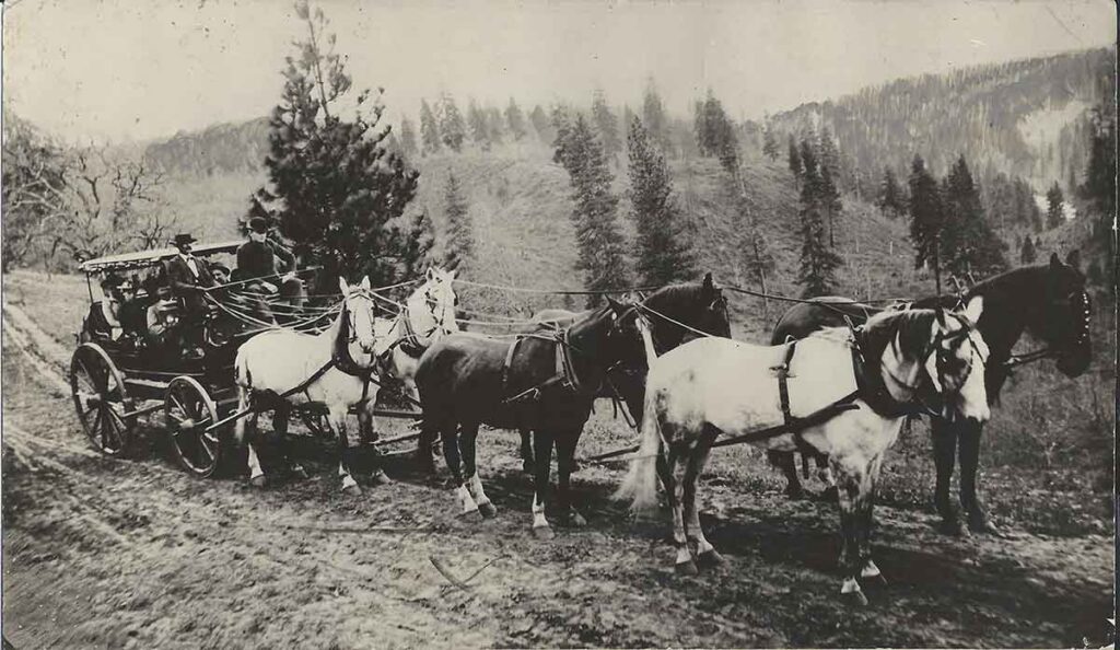
Map Turn – Mt Hood Highway 26

Make no mistake — that map up there is the real thing
by Paul Keller

HUNCHBACK MOUNTAIN — This dispatch is being written, believe it or not, inside “The Map” — approximately North Dakota, maybe eastern Montana.

If you’re new here, “The Map” is the namesake of Map Turn — Highway 26’s answer to the masked executioner.

Map Turn is the sweeping curve located west of Government Camp — just downslope from the new truck escape ramp — where several persons have perished in auto accidents in recent years. Eleven to date, according to Hoodland Fire Chief Don Arnimroot. (Interesting footnote: since the state highway department’s safety improvements were installed recently — including the truck escape ramp, new guardrails and better signing — Map Turn has failed to injure anyone!).

All past victims, however, failed to negotiate the fatal Map Turn bend: careening off the brim, down into the teeth of Laurel Canyon. D.O.A.

Hence, Map Turn — at least prior to these highway improvements — had achieved it’s own notoriety. Sort of a lethal hall of life hero. That potential executioner waiting to send the next unfortunate motorist on to St. Peter’s Gate.

But back to the story. Why tag it “Map Turn?” What and where is this “map,” anyway?

To understand the nomenclature, apply the brakes and pull your heap over on this popular corner. Then look west, my friend, look west.

Up there (the here where I now sit) on the eastern facing backbone of distant Hunchback’s ridge, you’ll see it. How unmistakable, really. The Map.

The map of our United States that is.

An almost perfect rendition, too. Including a well defined Florida, the New England states, and — who knows how — even Alaska. Shortcomings include an omission of the Hawaiian Islands and a dwarfed Texas. (Nobody’s perfect).

Now about those long mulled tales defending this as a logged parcel of land purposely chain-sawed and tailored by man. Pure hogwash.

Take it from this hiking boot sore reporter. The Map is a natural phenomenon. A field of giant gray boulders and a few stubborn trees.

Goodness knows how this big stone pockmark ever took on the spitting image of America the Beautiful.

In fact, maybe the roadside term shouldn’t be dismissed as simply the land-mark for a well known highway turn that affords an unblemished view of it.

Perhaps this mysterious handiwork by Mom Nature — or whatever deity you prefer — might be the Mount Hood Corridor’s own sleeping version to England’s intriguing Stonehenge.

At least an appreciative cartographical society might consider somehow honoring our natural tribute to the good old U.S. of A.

Well it’s high time I trudged back down and filed this story. What? How did I get up here in the first place? That’s for you to figure out.

Try using, pardon the repetition, a map.

The Legacy of Emil and Suzette Franzetti and the Rhododendron Inn

Inn Keepers Emil and Suzette Franzetti

A Historic Inn Lost to Time

Tucked beneath the towering firs of Mount Hood’s forests, the Rhododendron Inn once stood as one of Oregon’s most celebrated mountain retreats. Over time, it became a well-known stop for weary travelers, outdoor enthusiasts, and adventure seekers. Although the inn is now gone, its legacy remains woven into the region’s history.

Among the individuals who shaped its story, Emil and Suzette Franzetti stand out. Their journey was filled with ambition, hospitality, and resilience. They turned the Rhododendron Inn into a thriving mountain getaway. However, tragedy eventually struck, leaving behind a story of perseverance that helped define early tourism in Oregon’s Mount Hood region.

The Rhododendron Inn - Emil and Suzette Franzetti

The front of the old Rhododendron Inn

A Hotel in the Wilderness

The Rhododendron Inn was not originally the Franzettis’ creation. In 1905, Henry S. Rowe, a former Portland mayor, established the inn on 160 acres near the Zigzag River. His vision was to create a peaceful retreat for city dwellers in search of fresh air and mountain solitude.

To make this dream a reality, Rowe enlisted the help of Lee Holden, Portland’s fire chief at the time. With his assistance, the rustic yet elegant lodge took shape. As road conditions improved, more visitors arrived, and the inn’s popularity soared. Eventually, it became a well-known stop for those traveling toward Mount Hood.

By 1912 its ownership changed. Recognizing the inn’s potential, two seasoned hoteliers, Emil and Suzette Franzetti, stepped in to elevate its status.

The Rhododendron Inn - Emil and Suzette Franzetti

The Rhododendron Inn Interior

Emil Franzetti: A Chef for Kings

Born in Lugano, Switzerland, Emil Franzetti was not just an innkeeper—he was a renowned chef. His career took him across Europe, where he trained in some of the finest hotels. Over time, his skills became so refined that he even cooked for the King of Italy.

In 1905, Emil immigrated to the United States, determined to advance his career. After working in New York, Baltimore, and Washington, D.C., he settled in Portland. There, he became the head chef at The Quelle, a famous restaurant celebrated for its crawfish dishes.

The Rhododendron Inn - Emil and Suzette Franzetti
The Rhododendron Inn 1930

Despite his success, he longed for something different. For this reason, he and Suzette purchased the Rhododendron Inn in 1912. Their expertise and hospitality transformed the lodge into a premier mountain retreat.

A Premier Mountain Retreat

Under the Franzettis’ leadership, the Rhododendron Inn flourished. They expanded and enhanced the property, turning it into a highly sought-after destination.

Upgrades and Attractions:

  • A dance hall that hosted lively gatherings.
  • A spring-fed swimming pool for summer relaxation.
  • Tennis and croquet courts for sports enthusiasts.
  • Bridle paths and hiking trails, providing access to the surrounding forests.
  • Additional cottages and tent houses to accommodate more guests.

Emil’s warm hospitality made the inn unforgettable. Often, he personally caught fresh trout for guests, ensuring every meal was authentic and memorable. He was also an artist. The inn was decorated with his paintings. Furthermore, his world-class cuisine and welcoming personality helped solidify the Rhododendron Inn as one of Oregon’s most popular retreats.

Tragedy Strikes

While the inn thrived, misfortune struck the Franzetti family. On November 17, 1916, while traveling near Zigzag, Oregon, Emil’s car skidded off the road and overturned. A passing farmer eventually found him, trapped beneath the wreckage.

Rescuers rushed him to St. Vincent’s Hospital. Tragically, he never regained consciousness. At just 35 years old, Emil Franzetti passed away, leaving behind a thriving inn and a grieving wife.

His funeral took place at St. Mary’s Cathedral in Portland. To honor his memory, members of the Mazamas Mountain Climbing Club, of which he was a member, attended the ceremony. His loss devastated the Mount Hood community. Despite this, the Rhododendron Inn remained a beacon for travelers.

Suzette’s Determination

Although Emil was gone, Suzette Franzetti refused to let the Rhododendron Inn decline. Fluent in seven languages, she managed the business alone for seven more years.

Under her strong leadership, the inn continued attracting visitors. However, by 1923, she decided it was time to move on. She sold the Rhododendron Inn and subdivided much of the surrounding land.

Because of this, many properties in the area became home to Henry Steiner-built log cabins. These structures further enriched the architectural history of the region.

Franzetti Cabins, Rhododendron Oregon.
Franzetti Cabins

The Final Years of the Rhododendron Inn

Following Suzette’s departure, the inn passed through multiple owners. Each transition marked a new chapter, but the original spirit of the place remained.

  • In 1932, a fire destroyed the annex building.
  • In 1943, new owner Thomas Rex renamed it the Rex Inn.
  • In 1949, a blowtorch accident caused a fire, reducing the inn to ashes.

Today, the site where the Rhododendron Inn once stood is barely recognizable. It lies just south of the modern highway, near the suspension bridge over the Zigzag River. While no buildings remain, the memories endure.

The Rhododendron Tavern - Emil and Suzette Franzetti
The Rhododendron Tavern

The Lasting Legacy of the Franzettis

The story of Emil and Suzette Franzetti is not just about a lost inn. Instead, it stands as a testament to resilience, passion, and the pioneering spirit that shaped Oregon’s early tourism industry.

Though the Rhododendron Inn is gone, its impact remains. The Franzettis’ dedication helped develop the Mount Hood Highway, strengthening Rhododendron’s identity as a premier travel destination.

Next time you pass through Rhododendron, Oregon, take a moment to reflect. Picture the grand inn that once stood among the trees—its dance halls filled with music, fireplaces crackling with warmth, and Emil himself preparing fresh mountain trout for a guest.

Although time has erased the Rhododendron Inn, the spirit of Emil and Suzette Franzetti still lingers in the heart of Mount Hood’s history.

Do You Love Mount Hood History?

If you enjoyed this story, explore more forgotten tales of Oregon’s past on MountHoodHistory.com.

Have memories or stories about the Rhododendron Inn? Share them in the comments below!


Howard’s Hotel at Sharon Springs: A Lost Piece of Zigzag’s History

A Mysterious Rock Wall and a Forgotten Hotel

As you drive along the east end of Barlow Trail Road near the confluence of the Sandy and Zigzag Rivers, you may notice an old moss-covered rock wall. Weathered by time and nature, this beautifully crafted basalt and stone wall stands as a silent sentinel to the past. Yet, few—if any—know its origins. A 1920 map already labeled it as an “old rock wall.” Historical accounts mention it as a marker near old bridge brow logs from an original Barlow Trail crossing. But why was it built? What once stood behind those stones?

Piecing together historical maps, newspaper articles, and land records points to one answer: Howard’s Hotel at Sharon Springs. Built in the early 1910s, this long-forgotten inn lasted only a few years before fire destroyed it. Unlike the well-remembered Welch’s Hotel in Welches, McIntyre’s early hotel, or the Rhododendron Inn, Howard’s Hotel vanished from collective memory. Yet, its story is worth rediscovering.

The Mount Hood Road and the Growth of Tourism

The land where Howard’s Hotel stood was known as Sharon Springs, named after a small, year-round spring that still flows into Clear Creek near the Sandy and Zigzag Rivers. W.R. McGarry originally owned the land and subdivided it in the early 1900s as tourism in the Mount Hood region grew.

This growth followed the expansion of the Barlow Road, a pioneer-era route that later became a toll road. By the early 1900s, it transitioned into an automobile road, drawing more visitors. Travelers sought lodging along the way to Government Camp and Mount Hood’s higher elevations. Hotels and lodges sprang up to serve them.

Seeing an opportunity, Mr. and Mrs. Archibald Howard built a hotel at Sharon Springs, close to the Barlow Road and Mount Hood’s foothills.

Howard’s Hotel: Built for the Boom

Constructed in 1910, Howard’s Hotel was a three-story, 14-room cedar structure. It stood on the north side of the Sandy River along the old north bank road.

From the start, challenges arose. In 1911, a freshet washed away a crucial bridge over the Sandy River near the hotel and damaged two others, the Zigzag River and Bear Creek bridges. Access became difficult, forcing visitors to detour through Brightwood, where J.T. McIntyre had built a bridge.

Plans to rebuild the bridges were made, but the setback likely hurt the hotel’s early success. Meanwhile, competitors like Welch’s Hotel and the Rhododendron Inn thrived with easier access.

The Fire That Erased Howard’s Hotel

On a September night in 1912, disaster struck.

A report in The Oregonian (September 14, 1912) stated:

“The home of Mr. and Mrs. S. Howard, near the junction of Sandy and Zigzag River, in the Mount Hood district, known as the Howard Hotel, was destroyed by fire a few nights ago, and Mrs. Howard, who was alone at the time, barely escaped with her life. Fire started in the lower story from sparks from the fireplace after Mrs. Howard had retired for the night in an upper room.”

Mrs. Howard woke to flames blocking the stairs. Forced to escape through a side window, she fled in her night robe.

The hotel burned completely, with nothing saved. The financial loss ranged from $3,500 to $4,000. With no efforts to rebuild, Howard’s Hotel disappeared from both the landscape and local memory.

Why Has Howard’s Hotel Been Forgotten?

Unlike Welch’s Hotel, the Rhododendron Inn, or McIntyre’s Hotel, Howard’s Hotel lasted barely two years. No surviving photographs or major advertisements recorded its existence. Without a rebuilt structure or continued operation, history left it behind.

Nearby hotels thrived because they became part of a lasting tourism infrastructure. Welch’s Hotel evolved into the town of Welches. Rhododendron and Government Camp grew into permanent tourism hubs. But Howard’s Hotel faded, leaving only the rock wall as a possible clue to its past.

A Call for Further Investigation

The rock wall remains the only visible evidence of Howard’s Hotel. Its basalt and stone construction, multiple entryways, and elevated stone columns suggest more than a simple boundary wall.

Could forgotten records, lost photographs, or hidden remnants beneath the forest floor reveal more?

For now, the story of Howard’s Hotel at Sharon Springs remains an intriguing historical mystery—one that deserves to be remembered.

Conclusion: Preserving the Lost History of Howard’s Hotel

Howard’s Hotel burned in 1912, but its legacy should not be forgotten. Among the histories of Welches, Brightwood, and Rhododendron, it represents the challenges of early tourism in the Mount Hood wilderness.

Next time you pass through Zigzag, take a moment to consider the rock wall, the spring at Sharon Springs, and the stories hidden beneath the surface.

The past is still there—waiting to be uncovered.

Arrah Wanna Hotel in Wemme Oregon

A History of Arrah Wanna

The Birth of Arrah Wanna Hotel

Nestled in the picturesque surroundings of the Salmon River in Wemme, Oregon, the Arrah Wanna Lodge began its story in 1909 when George Routledge acquired 160 acres of timberland. At the time, the land sat about a mile from the nearest automobile road, making it an ideal mountain retreat.

That same year, the Mount Hood Hotel Company, led by C. W. Kern, J. R. Routledge, and R. Woods, announced plans to construct a Swiss Chalet-style hotel. Kern had previously operated the Welches Hotel for five years. By 1910, construction had begun on an 80 x 90-foot, two-story building with 40 rooms and wide verandas. The hotel featured rough timber finishes, large stone fireplaces, and running water. The estimated construction cost reached $20,000, and the hotel planned to open for the 1910 season.

Early Years and Challenges

Although the hotel was completed, financial struggles soon arose. Nevertheless, its location and design attracted conventions and gatherings, including a YMCA conference in 1916. Despite these successes, ownership changed in 1918 when J. L. Bowman of the Brownsville Woolen Mill Store in Portland purchased the property. Bowman then leased the hotel to Mr. and Mrs. George L. Spencer, who enhanced its reputation as a high-class resort. They introduced specialty meals, such as chicken dinners and the famous “Spencer Hot Gingerbread.” A giant fir tree near the hotel became a major attraction, measuring 41 feet in circumference and 300 feet tall.

A Tragic Fire and Rebirth

On June 5, 1922, tragedy struck when the Arrah Wanna Hotel burned to the ground. Strong winds fanned the flames, reducing the wooden structure to ruins in just 30 minutes. Fortunately, the surrounding cottages and J. L. Bowman’s summer home survived the disaster.

Determined to rebuild, Bowman oversaw the construction of a new hotel by May 1924. The new lodge featured 17 guest rooms and 10 bungalows. Built primarily of native fir with hard maple floors, the hotel also included modern conveniences. An electric plant at the Salmon River provided power, while hot and cold running water improved guest comfort. Traditional activities such as hiking, trout fishing, and berry picking remained popular. Additionally, a boardwalk along the river and new bungalows enhanced the visitor experience.

Growth and Changing Management

John L. Bowman passed away in July 1928. As the president of the Brownsville Woolen Mills, he had played a significant role in the history of the Arrah Wanna Hotel for a decade.

Throughout the 1920s and 1930s, the Arrah Wanna Hotel underwent various management changes and improvements. Advertisements promoted dining options, including their specialty $1.50 chicken dinners with mashed potatoes and gravy. Entertainment such as music, dancing, and campfire gatherings enriched the guest experience. By 1936, the lodge began serving beer under a new license. Despite these efforts, financial difficulties persisted, leading to periodic closures and the hotel being listed for sale or lease.

Oregon Baptist Church Buys Arrah Wanna

In 1941, the lodge entered a new chapter when a Baptist church group purchased the property for $12,750. Their vision was to create a summer camp, leading to the birth of Camp Arrah Wanna. That summer, the camp hosted its first youth retreat. A five-year improvement plan soon followed, adding a Bible house, tabernacle, dining hall, and swimming pool. Over time, the camp became a cornerstone for religious retreats and youth activities in the area.

Into Modern Times

By 1952, a new swimming pool was constructed, and in 1962, $50,000 was allocated for further improvements. Beginning in 1969, Camp Arrah Wanna became one of the locations hosting Portland Public Schools’ Outdoor School program. During this six-day outdoor experience, sixth-grade students learned about science and nature while immersing themselves in the wilderness.

Today, Camp Arrah Wanna remains under the ownership of the American Baptist Churches of the Central Pacific Coast. It serves as a retreat and recreational facility, also hosting conferences and events for various groups.

Legacy of the Arrah Wanna Hotel

From its early days as a luxurious mountain hotel to its transformation into a church camp and community center, the Arrah Wanna Hotel has played a vital role in Oregon’s history. Its scenic location, engaging activities, and mountain lodge charm continue to captivate visitors. As a beloved landmark in the Mount Hood area, its legacy endures, reflecting the rich heritage of the region.

Fires, Fear, and Fighting Back: The Week the Forest Burned Near Mt. Hood

The Forest Fires of October 13-17, 1952

A Dry Season Sparks Trouble

Late in the season, around midnight on October 13, 1952, trouble began in the dry forests surrounding Mt. Hood. Flames appeared south of the Mt. Hood Highway, just east of Rhododendron, near Yocum Falls. As the fire moved down through Laurel Canyon, it stretched toward Flag Mountain. Initially, officials suspected a tree had fallen on a power line, sparking the blaze. However, the Sandy Electric Company suggested that men violating the hunting ban may have started the fire instead of the 33,000-volt power line.

Mt Hood National Forest Fires of October 1952

Fires Spread Across the Region

Meanwhile, a second fire erupted when windblown embers ignited dry vegetation near Still Creek, along the north slope of Zigzag Canyon. As a result, flames threatened summer homes and caused landslides, sending large rocks tumbling toward the Zigzag River. Consequently, firefighters faced an increasingly dangerous situation.

By Tuesday, October 14, another fire had ignited. This time, flames burned up Henry Creek toward Devils Canyon near Rhododendron. Since dry east winds were blowing with typical intensity, they fanned the flames. Therefore, firefighters struggled to contain the rapidly spreading fires.

Mt Hood National Forest Fires of October 1952

Road Closures and Evacuations

Due to the growing danger, officials closed the Mt. Hood Highway. Roadblocks went up in Sandy and Bend, allowing only emergency vehicles and buses to pass. As a precaution, traffic had to be rerouted through the Columbia River Gorge or the North Santiam Highway. Firefighters hosed down wooden bridges along the highway while residents sprayed their roofs with water, trying to keep embers at bay. Understandably, people in Rhododendron prepared to evacuate if necessary. The county’s civil defense agency remained on high alert, ready to assist should homes become threatened.

Mt Hood National Forest Fires of October 1952

Arson Suspected in Brightwood

By Wednesday, October 15, conditions worsened. A third fire ignited near Brightwood around noon. Flames burned through thick ferns and second-growth timber. Unfortunately, local residents reported seeing two teenage boys speeding away in a blue coupe just before the fire started. Consequently, police issued an alert, but the suspects were never found.

Mt Hood National Forest Fires of October 1952

A Threat to Bull Run Watershed

By Thursday, October 16, tensions ran high. The Brightwood fire moved toward the Bull Run watershed, the primary water source for Portland. Since winds carried the flames up Boulder Creek, they brought them dangerously close to Bull Run. Meanwhile, in Rhododendron, a 120-man crew worked tirelessly to build a fire line around the Henry Creek blaze. More than 400 firefighters battled flames across the region. At the same time, at Zigzag Ranger Station, local women volunteered to prepare sandwiches, helping to sustain the exhausted fire crews.

Mt Hood National Forest Fires of October 1952

Firefighters Gain Control

Finally, on Friday, October 17, firefighters gained the upper hand. Crews, totaling 700 men, worked around the clock to contain the fires. By this point, the Brightwood blaze alone had consumed between 300 and 400 acres. In total, an estimated 1,200 acres burned before firefighters managed to control the destruction. Despite the progress, northeast winds and low humidity kept everyone on edge, hoping for much-needed rain.

Mt Hood National Forest Fires of October 1952

A Community United

In the aftermath, the fires left a lasting impact. However, they also demonstrated the strength of the community. Firefighters risked everything to contain the flames, while residents took action—hosing down homes, preparing food, and offering support. Although the forest would recover, the stories of that harrowing week of the Forest Fires of 1952 would endure for generations.

Mt Hood National Forest Fires of October 1952

Preserving the History

These photos are scanned from negatives in my personal collection, capturing the unforgettable events of that historic fire.

Mt Hood National Forest Fires of October 1952

Portland’s Buffalo Bill – William DeVeny

Zigzag Cabin Owner: A Local Legend

In the early 1900s, Portland’s Montavilla neighborhood was home to one of its most fascinating figures: Dr. William DeVeny. Known as the “Buffalo Bill of Portland,” William DeVeny was a community leader, civic advocate, and larger-than-life character. His influence stretched beyond Montavilla and into the Mount Hood region, where he worked to improve access to the wilderness.

DeVeny’s striking appearance—long hair, a thick beard, and signature buckskin attire—earned him his nickname. According to some accounts, Buffalo Bill Cody himself gave him the title. Yet, DeVeny was more than just a local icon—he was a man of action.

A Visionary for Montavilla

DeVeny dedicated himself to improving Montavilla. As secretary of the Montavilla Board of Trade, he led efforts to attract new businesses, including a fruit cannery, chair factory, and broom factory. He also pushed for better schools, clean water, and libraries, believing these essentials would help Montavilla thrive.

One of his most ambitious projects was Montavilla’s annexation to Portland. He argued that annexation would bring stronger infrastructure, including deeper water mains to prevent freezing and increased school funding. Although his campaign initially failed, he continued to fight for it.

In 1907, he ran for city council, hoping to create more change. However, his campaign faced controversy when petition collectors submitted duplicate signatures. Though DeVeny did not commit fraud, officials removed his name from the ballot. This setback ended his political aspirations, but not his commitment to the community.

He saw the need for better roads in the region. To improve access, he led the construction of a road connecting the Mount Hood automobile road to Truman Road on the north side of the Sandy River. The project, called DeVeny Road, required the building of several bridges. This new route made travel easier for settlers, forest rangers, and tourists.

Building Roads to Mount Hood

DeVeny’s passion for development extended into the Mount Hood wilderness. He owned a cabin near the mountain, which he called The Scout’s Rest, inspired by Buffalo Bill Cody’s Nebraska ranch.

By 1913, construction was complete. This road became a key link for travelers and helped boost tourism in the Mount Hood region. Eventually, it was renamed Lolo Pass Road, but DeVeny’s work remains a vital part of the area’s history.

A Complex and Evolving Figure

DeVeny’s views changed over time. Once a supporter of military training for boys, he later spoke out against war, particularly as World War I approached. Some believe he changed his stance because his sons became eligible for the draft.

Beyond civic work, DeVeny was a skilled chiropodist (foot doctor) and an accomplished photographer. Alongside his wife, Martha, he operated photography studios before settling in Portland.

He also supported women’s suffrage and equal rights, reflecting a progressive mindset that was ahead of his time.

A Lasting Legacy

Dr. William DeVeny passed away in 1918 at age 65. The Oregonian honored him as a civic leader, community advocate, and friend of famous frontiersmen. His contributions to Montavilla and Mount Hood shaped Oregon’s history in ways still seen today.

Today, hikers in Mount Hood’s forests and residents in Montavilla’s streets walk paths influenced by his work. His life is a powerful reminder of how one determined individual can shape a community’s future.

The Modern Barlow Trail Road

The Historic Paths of Barlow Trail Road and Lolo Pass Road

Have you ever driven along Barlow Trail Road or Lolo Pass Road and wondered about their origins? These quiet, winding roads are more than just modern routes—they are living pieces of history.

Long before cars or bicycles rolled over them, these paths were game trails and footpaths used by the region’s first inhabitants. Later, Oregon Trail pioneers relied on them as lifelines to complete their westward journey. Over time, they evolved into crucial connections for local residents and the modern communities we know today.

  and wondered about their origins? These quiet, winding roads are more than just modern routes—they are living pieces of history.

From Wagon Wheels to Hackett Road

In the mid-1800s, the original Barlow Trail served as a rough but vital route for settlers completing the Oregon Trail. As pioneers descended from Mount Hood, they followed the north side of the Zigzag River until they reached the Sandy River. At the big bend of the Sandy, they crossed over a log bridge built by settlers.

Later, the trail shifted to the south side of the Sandy River, leaving behind remnants of the earlier path. As a result, settlers repurposed parts of the old trail into local roads, including Hackett Road. This road, named after early settlers in the area, still carries their legacy in the name of nearby Hackett Creek.

The McIntyre Bridge: A Critical Connection

By 1910, settlers struggled to access the road on the north side of the Sandy River. Early bridges were unstable and often washed away, making travel difficult. That year, J.T. McIntyre, an early settler in Brightwood, took action. He built a sturdy bridge over the Sandy River, providing reliable access to the road on the north side.

This new bridge transformed travel in the area. Residents could now cross the river safely, and it became a key link for the growing community. Without McIntyre’s efforts, settlers on the north side would have remained isolated from the developing Mount Hood automobile road nearby. Consequently, his work played a crucial role in connecting these remote settlements.

  and wondered about their origins? These quiet, winding roads are more than just modern routes—they are living pieces of history.

The Road to The Truman Farm

Around the same time, Ezra and Eliza Truman homesteaded on the north side of the Sandy River, near Zigzag Ridge. Ezra, a mountain guide and farmer, relied on the newly connected road to reach his homestead. He used it to deliver milk and produce to his neighbors.

Over time, this route became known as Truman Road, named after the family who lived at its farthest end. Even after Ezra’s death in 1917, the road remained essential. It provided access to settler homes, cabins, and lodges, supporting the early tourism industry that grew alongside the increase in automobile travel to Mount Hood. Because of this, the area became a gateway for visitors exploring the region.

  and wondered about their origins? These quiet, winding roads are more than just modern routes—they are living pieces of history.

DeVeny Road: A Valuable Connection

In the early 1900s, Dr. William DeVeny, a Zigzag cabin owner and civic leader from Montavilla (now part of Portland), saw the need for better road access. With support from the Mount Hood Improvement Association and local government funding, he led the construction of DeVeny Road.

The new road linked the Mount Hood automobile road on the south side of the Sandy River to the east end of Truman Road on the north side. By 1913, the project was complete. Bridges were built over Bear Creek, the Zigzag River, and the Sandy River, creating a vital route for settlers, forest rangers, and early visitors to the Mount Hood wilderness. As a result, travel between the two sides of the Sandy River became much easier, further opening the area to development.

  and wondered about their origins? These quiet, winding roads are more than just modern routes—they are living pieces of history.

A Modern Legacy

As time passed, these roads continued to serve local communities while adapting to modern needs. In 1979, the Clackamas County Historical Society honored the pioneers by renaming Truman Road to Barlow Trail Road. This change recognized the historical importance of the original Barlow Trail.

Meanwhile, DeVeny Road became part of Lolo Pass Road, and its original name faded from memory. Yet, the routes themselves remain a testament to those who built them. Although the names have changed, their significance has not been forgotten.

Roads Worth Remembering

Today, whether you’re coming home, heading out, or simply enjoying a scenic drive, you are traveling through history. These roads are more than just asphalt and gravel—they are stories of resilience, determination, and community.

So, next time you find yourself driving down Barlow Trail Road or Lolo Pass Road, take a moment to appreciate the history beneath your wheels. After all, you are following in the footsteps and wagon tracks of those who came before us

  and wondered about their origins? These quiet, winding roads are more than just modern routes—they are living pieces of history.

The Mountain View Inn

A Lost Landmark of Government Camp

This historic photo captures the Mountain View Inn under heavy snow during the 1940s. Once a well-known hotel in Government Camp, Oregon, the inn played a key role in the town’s early ski culture. However, in 1955, a fire destroyed the building, leaving only memories behind.

A Pioneer Homestead Becomes a Hotel

The building originally belonged to Lena Little, wife of Francis C. Little, a pioneer homesteader. It first served as a private residence, but later, workers moved it to the north side of the main road in Government Camp. This relocation allowed it to become a hotel, serving visitors drawn to the growing ski scene.

Jack Rafferty’s Lodge and the War Years

After the move, Jack Rafferty leased the building and transformed it into a hotel and ski lodge. At first, he named it Rafferty’s or Rafferty’s Hut. Later, he purchased the property, establishing it as a local business.

During its early years, the hotel also went by the name Tyrolian Lodge, reflecting Government Camp’s Alpine influence. However, World War II forced the hotel to close, as tourism slowed and many businesses struggled.

A New Era: The Mountain View Inn

After the war, Harry Albright reopened the lodge and renamed it The Mountain View Inn. As tourism grew, Government Camp became a major skiing destination. With more visitors arriving, the inn became a popular stop for travelers heading to Mount Hood.

A Fiery End in 1955

In 1955, tragedy struck when the Mountain View Inn burned down. It once stood across the street from Daar’s Ski Shop, which later became Charlie’s Mountain View, a well-known landmark today.

Although the inn is gone, its history survives through photographs and stories. This image, showing the snow-covered hotel, serves as a reminder of Government Camp’s past and its early skiing culture.

The Mt Hood Skiway Tram
. The Mount Hood Aerial Transportation Company was formed with a plan to create an aerial tramway to Timberline Lodge on the south slope of Mount Hood from Government Camp, the gathering spot for every activity on The Mountain. It was to be called The Skiway

Tawney’s Mountain Home

Tawney’s Mountain Home: A Forgotten Retreat in Welches, Oregon

A Hidden Gem in the Salmon River Valley

In the early days, the Welches Hotel wasn’t the only resort in the Salmon River Valley at the base of Mount Hood. About a mile past the Welches property, at the end of the road, sat Tawney’s Mountain Home. Surrounded by wilderness and nestled along the Salmon River, this hotel operated as a popular outdoor vacation spot from 1910 to 1945.

Hotel Maulding, welches Oregon

From Homestead to Hotel

The hotel was originally part of the Walkley family homestead, located south of Welches. While the Walkleys didn’t run a formal hotel, they did take in boarders. In 1906, John Maulding and his wife purchased the 100-acre property, which included the Walkley home. They remodeled and expanded the house, converting it into what became known as Maulding’s Hotel.

In 1909, Francis H. Tawney and his wife, Henriett, leased the property. A year later, they purchased it and began making improvements. However, in 1913, a fire destroyed a large portion of the original hotel. Undeterred, the Tawneys built a two-story addition, and by 1914, the new Tawney’s Hotel was welcoming guests once again.

Tawney's Hotel, Welches Oregon

A Grand Lodge with Rustic Charm

Tawney’s Hotel was a large two-story building with 15 guest rooms. Due to its popularity, tent cabins were added on the grounds to accommodate additional visitors.

Guests entered through a spacious living area featuring a large rock fireplace. A grand staircase led to the second floor, where the guest rooms were located. Connected to the living room, a huge dining room offered another stone fireplace and a long dining table for communal meals.

The hotel had only one indoor bathroom, located off the dining room. It included a commode and a bathtub, making reservations nearly necessary for guests who wanted to use it.

A Stay at Tawney’s Mountain Home

A week’s stay at the hotel cost $10, including meals. Mrs. Tawney, with help from her daughter-in-law, Emily, prepared food for guests. Meals were served family style, with platters of chicken, roast beef, and steak. Fresh bread, jams, canned foods, and homemade pies were always available. Mrs. Tawney also made large sugar cookies for the children, though adults often raided the cookie jar as well.

Keeping the kitchen stocked was no small task. Up to 150 guests might arrive for Sunday dinner, requiring a constant supply of food. Staples and canned goods were delivered weekly from Portland, while a butcher wagon from Sandy made daily summer deliveries, bringing cuts of beef and lamb packed in ice.

Tawney's Mountain Home, Welches Oregon

Living Off the Land

The Tawneys maintained their own livestock, including cows, pigs, and chickens. Guests could ride horses, and children often enjoyed rides on the two donkeys.

Mr. Tawney frequently took guests on wagon trips to Government Camp for huckleberry picking and picnic lunches. The property also included a large garden, an apple orchard, and wild berry patches for pie-making. Guests sometimes supplied trout from the Salmon River and local creeks, adding to the hotel’s menu.

In 1910, a group of three fishermen—B. Trenkman, C.J. Cook, and L. Therleson—ventured to Camp Creek for a fishing trip. They returned 1.5 hours later with 286 trout, making it one of the most legendary meals ever served at Tawney’s Mountain Home.

Tawney's Mountain Home, Welches Oregon

A Place for Summer Memories

Longtime Welches resident Nell Howe recalled that summer days at Tawney’s were filled with wonderful food and laughter. She said, “In the summertime, the tables in the dining room were full for every meal, and sometimes people were waiting their turn.”

Many guests fondly remembered their time at the lodge—swimming in the river, fishing, helping with chores, and enjoying the delicious home-cooked meals.

Tawney's Mountain Home, Welches Oregon

The End of an Era

By 1945, Tawney’s Mountain Home closed its doors, likely due to declining business and wartime shortages. The Tawneys, now older, stepped away from the demanding work of running the hotel.

Mr. Tawney passed away in 1947, and soon after, Mrs. Tawney moved to Portland to live with her daughter and son-in-law. She remained there until her passing in 1959.

A Fading Legacy

In the late 1950s, the abandoned lodge collapsed under the weight of a heavy snowstorm. A new owner later purchased the land and demolished the remains, leaving only the two original stone fireplaces standing.

Today, these fireplaces serve as the last visible reminders of Tawney’s Mountain Home—a once-thriving piece of Welches, Oregon’s history

Oregon pioneer history
Oregon pioneer history (1806–1890) is the period in the history of Oregon Country and Oregon Territory, in the present day state of Oregon and Northwestern

The Lil Toot Drive-In

Wimpy’s Lil Toot Drive-In: A Lost Piece of Kelso, Oregon’s History

A Once-Popular Stop on the Mount Hood Highway

During the time when Orient Drive served as the main highway to Mount Hood, Clarence “Wimpy” Eri operated Wimpy’s Lil Toot Drive-In in Kelso, Oregon. The small drive-in, located across from the Kelso Store, became a popular stop for travelers heading to the mountain. Locals also frequented the spot, enjoying a quick meal and friendly service.

For years, the old highway route directed steady traffic through Kelso, keeping businesses like Wimpy’s thriving. The drive-in benefited from visitors who wanted a convenient place to grab food before continuing their journey. However, the construction of modern Highway 26 in the mid-1960s redirected traffic away from the town. With fewer customers, many small businesses, including Wimpy’s Lil Toot Drive-In, struggled to survive and eventually closed.

A Personal Connection to Wimpy’s Lil Toot

Kelso, Oregon, sits just west of Sandy, between Sandy and Boring. While many remember Wimpy’s Lil Toot Drive-In as a favorite roadside stop, others have a more personal connection to it.

One local recalls eating there many times as a young boy, as Clarence “Wimpy” Eri was a relative. The drive-in stood at the west side intersection of Kelso Road and Orient Drive, directly across from the Kelso Store. Families and travelers enjoyed the convenience of a small-town diner along what was once the primary route to Mount Hood.

A Lost Landmark of the Past

Although Wimpy’s Lil Toot Drive-In no longer stands, its memory remains part of Kelso’s history. The intersection of Kelso Road and Orient Drive, where it once stood, still echoes the past, reminding us of a time when small roadside diners thrived along the highway to Mount Hood.

This small, family-run business was one of many that once lined the old highway, catering to travelers who needed a break before heading further up the mountain. Today, while the landscape has changed, memories of places like Wimpy’s Lil Toot Drive-In live on through stories and those who remember stopping there for a meal.

Wimpy’s Lil Toot Drive-In: A Lost Piece of Kelso, Oregon’s History