
The Forest Fires of October 13-17, 1952
A Dry Season Sparks Trouble
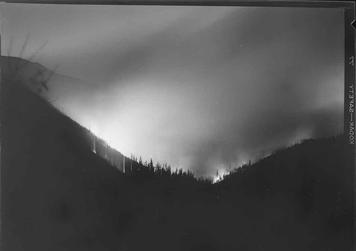
Late in the season, around midnight on October 13, 1952, trouble began in the dry forests surrounding Mt. Hood. Flames appeared south of the Mt. Hood Highway, just east of Rhododendron, near Yocum Falls. As the fire moved down through Laurel Canyon, it stretched toward Flag Mountain. Initially, officials suspected a tree had fallen on a power line, sparking the blaze. However, the Sandy Electric Company suggested that men violating the hunting ban may have started the fire instead of the 33,000-volt power line.

Fires Spread Across the Region
Meanwhile, a second fire erupted when windblown embers ignited dry vegetation near Still Creek, along the north slope of Zigzag Canyon. As a result, flames threatened summer homes and caused landslides, sending large rocks tumbling toward the Zigzag River. Consequently, firefighters faced an increasingly dangerous situation.
By Tuesday, October 14, another fire had ignited. This time, flames burned up Henry Creek toward Devils Canyon near Rhododendron. Since dry east winds were blowing with typical intensity, they fanned the flames. Therefore, firefighters struggled to contain the rapidly spreading fires.

Road Closures and Evacuations
Due to the growing danger, officials closed the Mt. Hood Highway. Roadblocks went up in Sandy and Bend, allowing only emergency vehicles and buses to pass. As a precaution, traffic had to be rerouted through the Columbia River Gorge or the North Santiam Highway. Firefighters hosed down wooden bridges along the highway while residents sprayed their roofs with water, trying to keep embers at bay. Understandably, people in Rhododendron prepared to evacuate if necessary. The county’s civil defense agency remained on high alert, ready to assist should homes become threatened.

Arson Suspected in Brightwood
By Wednesday, October 15, conditions worsened. A third fire ignited near Brightwood around noon. Flames burned through thick ferns and second-growth timber. Unfortunately, local residents reported seeing two teenage boys speeding away in a blue coupe just before the fire started. Consequently, police issued an alert, but the suspects were never found.

A Threat to Bull Run Watershed
By Thursday, October 16, tensions ran high. The Brightwood fire moved toward the Bull Run watershed, the primary water source for Portland. Since winds carried the flames up Boulder Creek, they brought them dangerously close to Bull Run. Meanwhile, in Rhododendron, a 120-man crew worked tirelessly to build a fire line around the Henry Creek blaze. More than 400 firefighters battled flames across the region. At the same time, at Zigzag Ranger Station, local women volunteered to prepare sandwiches, helping to sustain the exhausted fire crews.

Firefighters Gain Control
Finally, on Friday, October 17, firefighters gained the upper hand. Crews, totaling 700 men, worked around the clock to contain the fires. By this point, the Brightwood blaze alone had consumed between 300 and 400 acres. In total, an estimated 1,200 acres burned before firefighters managed to control the destruction. Despite the progress, northeast winds and low humidity kept everyone on edge, hoping for much-needed rain.

A Community United
In the aftermath, the fires left a lasting impact. However, they also demonstrated the strength of the community. Firefighters risked everything to contain the flames, while residents took action—hosing down homes, preparing food, and offering support. Although the forest would recover, the stories of that harrowing week of the Forest Fires of 1952 would endure for generations.
Preserving the History
These photos are scanned from negatives in my personal collection, capturing the unforgettable events of that historic fire.


Sources
- The Oregonian, August 22, 1933 — “Forest Fire Rages in Zigzag District.”
- The Oregonian, August 23, 1933 — “Crews Battle Flames in Mount Hood Forest.”
- The Oregonian, August 25, 1933 — “Rain Brings Relief to Fire Fighters Near Mount Hood.”
- The Oregon Journal, August 1933 — Coverage of the Mount Hood forest fire emergency.
- The Oregon Journal, August 26, 1933 — Reports on containment and damage in the Zigzag area.
- The Oregonian, September 1, 1933 — Retrospective summary of the fire’s impact.
- U.S. Forest Service fire reports, 1933 — Notes on Zigzag Ranger District and suppression efforts.
Again, Gary, thank you for your insightful story on this fire in our beloved area. It’s important that people stay aware and plan for the next big event.
Hi Marti! Thank you. You’re right. !!
Good stuff, Gary! Thanks. See also, “How Burnt Lake Got Its Name.”
http://portlandhistory.net/mounthoodhistory/2018/09/21/how-burnt-lake-got-its-name/
Hi Steve. I’ve written about that fire too. I hope that you’re doing great Steve. It would be good to see you again.
Gary,
Good stuff!!
The more that is written on the dangers of wildfire in our area, the better. History proves our forests are vulnerable. Our mountain community needs to continually be reminded that our area is not immune to the ravages of wildfire. Wildfires are historic in this area and it’s a question of when, not if , the next wildfire event threatens our neighborhoods. We need more Firewise® communities and more residents to clear defensible space around their properties, if we are to survive the next wildfire.
And this wasn’t the only one. The wildfires of 1931 and 1953 had the potential to burn this whole corridor to the ground too. I’m researching the recorded fires that have burned here in the past. I remember a couple of years ago when Wildcat Mountain was burning the winds were so severe that the fire would have burned right through if we were Firewise or not. There are too many trees. Firewise is good for other areas, but we have so much brush and trees around us. When Wildcat was burning, we evacuated to central Oregon. I think that a large threat that’s being ignored up here is all of the development that’s going in in the flood plane.
Hi Gary,
My name is Bree and I work for the Oregon State Fire Marshal. I came across the mthoodhistory.com website when I was doing research for our Mt Hood Conference room. We are hanging large metal print photos of the history there, and I was hoping to talk to you about using some from this article. They are amazing and we would love to showcase them in our building. Look forward to hearing from you! Thanks!
Hi Bree. Please email me at [email protected]