The Brightwood Museum and Novelty Shop—known to many locals as the Snake Pit—was once a popular roadside stop along the old highway to Mount Hood. Located at the intersection of Bridge Street and Brightwood Loop Road, it sits today in quiet decay near the Brightwood Store. But once, this log cabin-style building drew the attention of curious travelers and vacationing families.
Built by Henry Steiner, Master Cabin Builder
This unique structure holds special historical value because it was the final log building constructed by the legendary Mount Hood craftsman Henry Steiner. Best known for his iconic cabins and lodges across the region, Steiner built this structure specifically as a souvenir shop for tourists passing through Brightwood on their way to the mountain. Over the years, the building also served as a church, a private residence, and even briefly operated as a reptile garden.
The Road to Mount Hood: Slower Days, Quirky Stops
Before Highway 26 was widened and straightened into the fast-moving route it is today, a trip to Mount Hood was a leisurely journey. Especially after World War II, families packed their cars and hit the road in search of fresh air, fishing, and mountain recreation. Roadside attractions—often referred to as “tourist traps”—were part of the charm of the drive.
In addition to the Brightwood Museum and Novelty Shop, the area boasted other quirky destinations like the Swiss Gardensand the Mt. Hood Indian Pageant. These attractions helped define the postwar tourist era on the mountain’s south side.
A Local Landmark in Decline
Although time has taken its toll, the building still stands as a reminder of the golden age of roadside tourism. Sadly, it’s now deteriorating and largely forgotten. But for those who remember its heyday—or discover its story today—it remains a cultural landmark worth preserving in memory, if not in restoration.
If you’re driving through Brightwood, take a moment to stop by the parking lot of the Brightwood Store. You’ll find the old log structure still standing, weathered but resolute, whispering stories of a different time in Mount Hood’s history.
100 Years of Rhododendron Oregon and Mount Hood Tourism
I produced a video to commemorate the 100th anniversary of the little Mount Hood village of Rhododendron Oregon. It’s a collection that consists of photos that I’ve collected through the years and have added to my collection. There are a couple that are in the video that are copies of photos from the Welch Family as well as the family of Dr Ivan Wooley.
Located along the Mt. Hood Scenic Byway on a 19th-century pioneer wagon
route, Rhododendron nestles into the western flank of the craggy peak. The
terrain.
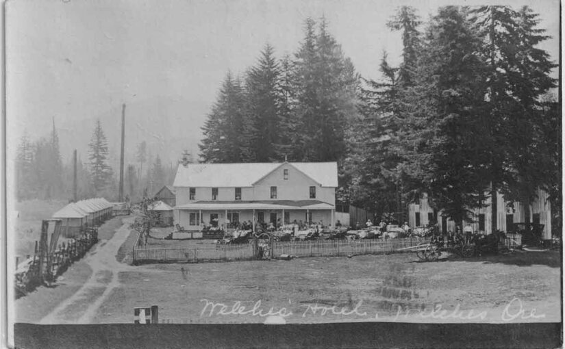
The history of the Welch’s Ranch in Welches Oregon begins in 1882. Before Welches became a popular destination, it was simply a family homestead ranch. Samuel Welch, an emigrant from Virginia, settled in the valley that year. Later, his son William “Billy” Welch and Edward Kopper, Billy’s first wife’s father, also homesteaded in the valley in 1889.
Establishing the Welch Ranch
Samuel and Billy Welch homesteaded adjoining 160-acre sections of the Salmon River Valley, located on the southwestern foothills of Mount Hood. Samuel’s homestead deed, signed by President Benjamin Harrison, was recorded in the Clackamas County Courthouse in 1893. Similarly, Billy’s deed, signed by President William McKinley, was recorded in 1898.
Over time, they expanded their holdings, acquiring nearly 1,000 acres that stretched from Walkley’s homestead in the south to “Dutch Fred’s” homestead in the north (near present-day Fairway Avenue). Their land also extended up the slopes of Hunchback Mountain to the east and Huckleberry Mountain to the west.
A Thriving Ranch and Early Tourism
The Welch Ranch was a fully operational farm with pastures, barns, and corrals for livestock, including dairy cows, beef cattle, sheep, and pigs. In addition, the family maintained an apple orchard, a large vegetable garden, and had access to abundant fish in the river and wildlife in the surrounding hills. A blacksmith shop and stables further supported the ranch operations.
As travel increased, the ranch became a stop for stagecoaches and later, motorized coaches en route to Mount Hood. Eventually, summer tourists began camping in the valley, taking advantage of its natural beauty.
Transition to a Resort
After Samuel’s death in 1889, Billy took over the ranch. Sadly, his first wife, Mamie Kopper Welch, passed away in 1902. By 1905, Clinton Kern and a Mr. Wren leased the property and opened a hotel resort, operating it until 1909. As part of the resort’s development, a large dining hall was built near the Salmon River to accommodate guests.
To replace the old dance hall, Billy expanded his store, adding a pool room and a second-story dance hall. Notably, the hall featured an east-facing balcony where dancers could cool off while enjoying views of Hunchback Mountain.
Community and Entertainment
In 1911, Billy married Jennie Faubion. Together, they managed the resort, store, post office, and dance hall. Meanwhile, the Welches Post Office had been established in 1905, with Billy serving as postmaster until 1940. Afterward, Jennie continued in the role until her retirement in 1960. Eventually, the post office moved to Wemme before returning to Welches.
The local community often gathered for bonfires, taffy pulls, and marshmallow roasts. Children collected wood for towering bonfires while families sang folk songs like “Ninety-Nine Blue Bottles.” Moreover, talented storytellers entertained crowds late into the night.
Saturday night dances were a highlight, drawing nearly everyone in town. Parents brought blankets for their children, who slept in the hall’s corners while lively fiddle music filled the air. Typically, Billy Welch and other local musicians played old-time tunes as dancers whirled through two-steps, schottisches, and waltzes.
Growth of Tourism
By 1910, Welches had become a sought-after summer destination. In addition to the Welches Hotel, nearby lodges such as Tawney’s Mountain Home, Arrah Wanna Lodge, and the Rhododendron Inn catered to vacationers. To meet increasing demand, Billy expanded the ranch into a full-fledged outdoor resort, adding tent cabins and campgrounds along the Salmon River.
As interest in the area grew, Billy allowed repeat visitors to camp on designated plots. Eventually, he subdivided and sold land for vacation cabins. The Kaderly family built the first vacation cabin south of the hotel by relocating Samuel Welch’s original homestead cabin.
Development of Local Businesses
Around 1885, Samuel Welch sold five acres to John and Mary Roberts of Gresham. Their son, Ed Roberts, worked in the Welches Store before marrying Dora Owens in 1903. Later, in 1913, Ed opened Roberts Country Store near the Welches Hotel, expanding the town’s commercial offerings.
The Welches Golf Course
In 1928, Ralph Waale leased Welch’s pasture and built a nine-hole golf course. He operated it until 1939, when ownership returned to the Welches. Shortly after, Billy and Jennie continued running the course until Billy’s passing in 1942. Over time, it changed hands multiple times before being sold to Eugene Bowman.
The Lasting Legacy of the Welch Ranch’s Ranch in Welches Oregon
Billy Welch played a pivotal role in shaping Welches into a tourist destination. His foresight in converting the ranch into a resort laid the foundation for the town’s growth. Though the original homestead is gone, the legacy of the Welch family endures in the community that still bears their name.
The Welch’s Ranch in Welches Oregon.
CLICK HERE to read more about the development of the Mt Hood Golf Course, Rippling River and the Resort on The Mountain.
The Crown Point Chalet was one of the premier roadhouses along the Historic Columbia River Highway back in the day. And the indefatigable Mrs M. E. Henderson was a key player in the early days of hospitality along the old road.
In 1912 a Mr. & Mrs. A.R. Morgan built the Chanticleer Inn on a promontory just east of Corbett, with an incredible view to the east of the scenic Columbia River Gorge, the Chanticleer Inn became a popular destination for Portland’s affluent on their forays into the scenic Columbia River Gorge. Managed by Mrs. M. E. (Margaret) “Bidy” Henderson the inn became known for its hospitality and its delicious meals. By the following year the new Columbia River Highway was being pushed through the Gorge. Mrs. Henderson left the Chanticleer Inn to start her own venture at Latourell Falls. She named it The Falls Chalet. She enjoyed great success at this beautiful road house with a spectacular view of the falls, but within a year it was destroyed by a fire.
Leaving Latourell and returning to the vicinity of the Chanticleer Inn she acquired a site on a promontory of land that would soon be the site of the Vista House, and a very popular stopping point for automobile tourists. It was here she decided to build The Crown Point Chalet. The Inn had a commanding view situated above and to the south of Crown Point.
The Crown Point Chalet opened for business in May of 1915. For over ten years Margaret enjoyed great success. But with the Depression looming and Mrs. Henderson’s health fading she sold the Chalet in 1927. Moving to Portland she started a very small dining room on Alder St. The Depression was the final blow and she went bankrupt. Her health worsened and in April of 1930 she passed away at the age of 58. Mrs. Henderson contributed greatly in the promotion and the successful completion of the Columbia River Highway.
The old lodge fell into disrepair and was demolished sometime in the early 1950’s.
“Cape Eternity” … Vista House … “Crown Point Falls” … Campsite of November 2,
1805 … Views from Crown Point … “Crown Point Chalet” … “Gardner’s Cafe” .
Cal Calvert and His Flying Studio: Postcard Photography in Early Portland
The Early Days of Photography
During the early days of photography, long before everyone carried a camera in their pocket, getting your photo taken was a special experience. By 1910, the consumer camera had only been available for about a decade. For many people, especially those in rural areas, a professional studio portrait with family or friends was a rare luxury—sometimes a once-in-a-lifetime opportunity.
Being a photographer in that era could be a decent living, but it wasn’t always easy. There was plenty of competition, so those in the trade had to get creative. Few photographers could rely on customers simply walking through their studio doors. Instead, many hit the road.
Postcards: The Social Media of Their Time
Photographers often traveled to scenic spots to shoot landscapes for use on postcards, which were in high demand with tourists. Others took a more personal approach—knocking on the doors of farmhouses and homes, offering on-the-spot portraits. Families would order copies and request postcards featuring their home, horse, or relatives, which they would then send to faraway friends and family.
Back then, postcards were one of the most popular ways to keep in touch. Telephones were still a luxury, cars were rare, and roads were rough. A quick phone call or road trip wasn’t usually an option. Letters were formal and often reserved for longer messages. In contrast, postcards were cheap, fast, and casual. Adding a photograph made them even better.
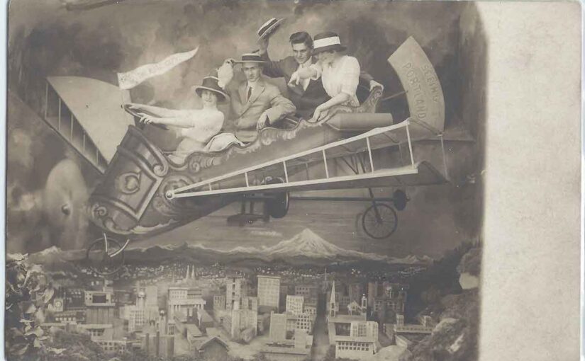
Meet Cal Calvert, the 10-Minute Postcard Man
One particularly creative photographer from Portland, Oregon stood out from the rest. His name was Charles “Cal” Calvert, and he became known for producing quick, personal photo postcards. He advertised himself as “Cal Calvert the 10 Minute Post Card Man.”
While most studios had a simple painted backdrop—usually a scenic view of the city with Mount Hood on the horizon—Cal went several steps further. His most memorable prop? A whimsical, homemade airplane with cockpits, designed for people to sit in and be photographed as if they were flying high above Portland.
Flying Over Portland… Sort Of
His “airplane” may not have been airworthy, but it was a hit with customers. People climbed in, smiled wide, and became airborne (at least in print). Behind them, the city of Portland stretched toward a dramatic skyline featuring the ever-present Mount Hood. The results were charming and lighthearted, especially in an era when most portraits were stiff and serious.
Calvert also offered other backdrop options—like a wood-and-ivy arbor for a more conservative look—but none captured the public’s imagination quite like the flying studio.
Mount Hood and the Portland Backdrop
Mount Hood shows up again and again in these postcards, and not just in Calvert’s work. Many photographers in Portland used hand-painted city scenes featuring Oregon’s iconic peak. Cars and planes—symbols of status and modernity—were often included as props. At a time when few people could afford such luxuries, being pictured next to one added a sense of aspiration and charm.
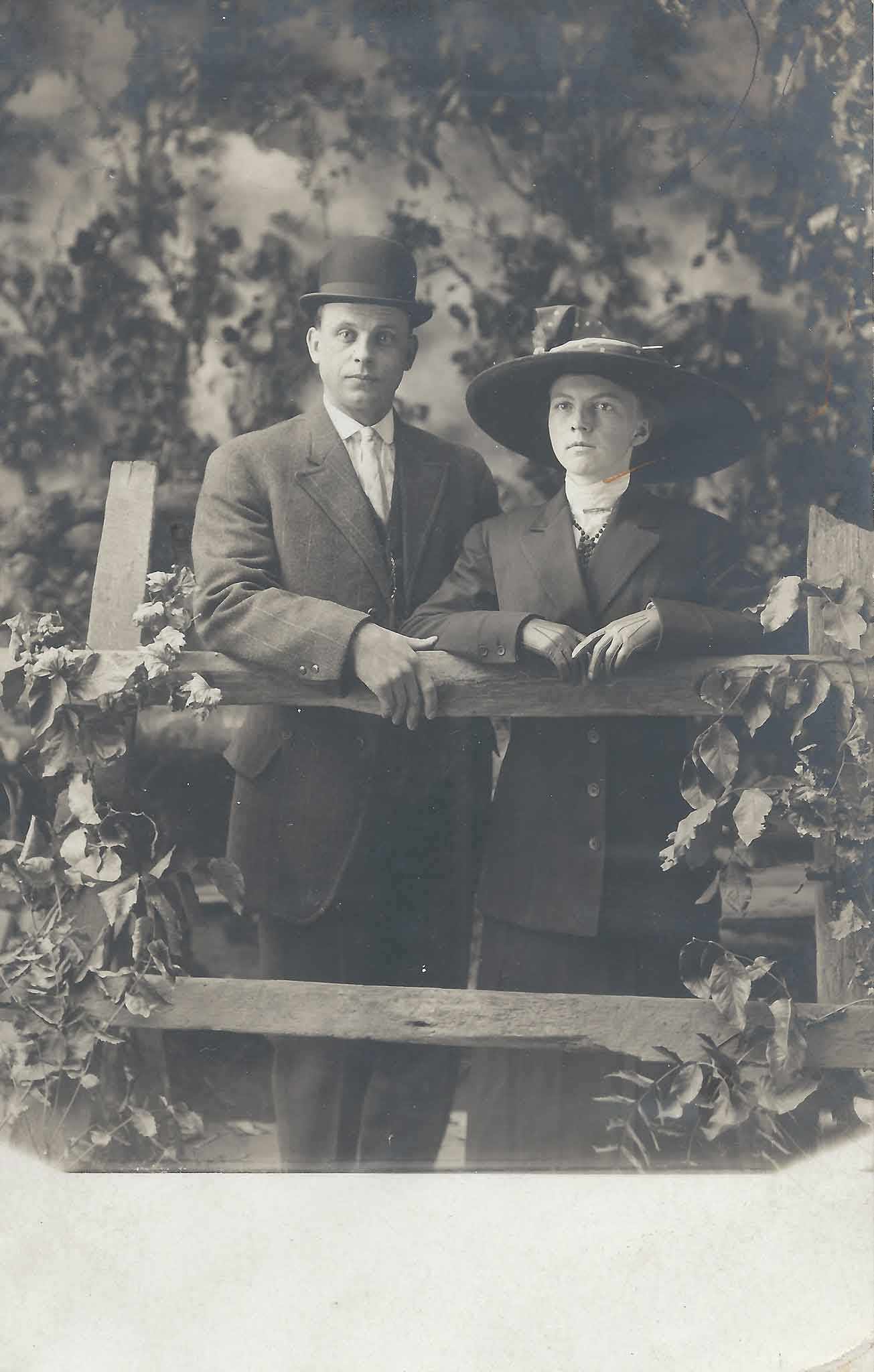
Faces from the Past
Over the years, I’ve collected a number of these photo postcards, including several created by Cal Calvert. For me, the best part is always the expressions on people’s faces. There’s a sense of fun, novelty, and pride in these portraits—even when they’re seated in a plywood plane.
I’ve also included some postcards with backdrops from other unidentified Portland photographers. Many of them still feature Mount Hood, and quite a few include cars or planes. They’re little slices of local history—nostalgic, imaginative, and uniquely Oregon.
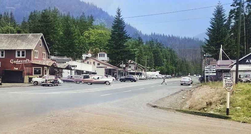
A lot has come and gone along the old Mt Hood Loop Highway, the name given for the route that started in Portland and followed old Highway 30 along the Historic Columbia River Highway to Hood River then along the present Highway 35 south from Hood River to Government Camp and the back to Portland via Highway 26, the route of the original Barlow Trail and the Mt Hood Highway. Of course it could be travelled in either direction, but either way the route would take one completely around Mount Hood. It’s still a very popular “Sunday drive” for those wanting to get away and see some scenery.
Things have changed through the years – Cars are faster and roads are better. Today one can take the drive and only stop for a quick lunch before they arrive back at home again all within a day, but there once was a time when folks would take the trip on the old Mt hood Loop and take a week long vacation to do it. During those times there were many more stops to be had along the way that were tourist draws such as restaurants, lodges, roadhouses and recreational activities. There were even more camping options back then.
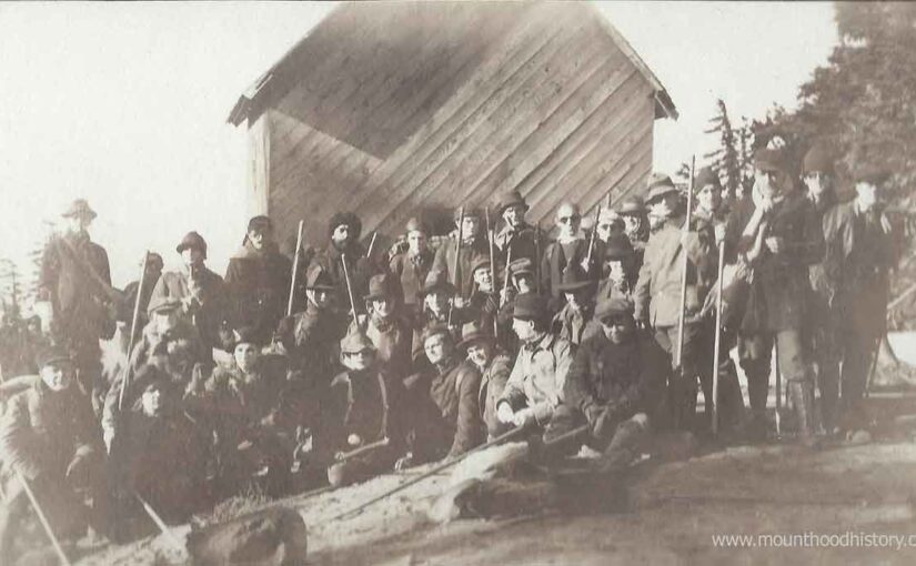
Much of this activity took place prior to World War II but the boom happened soon after the end of the war. Post World War II saw more people able to afford cars and free time and the roads and automobiles were improved. At that time a lot of soldiers were back home from the war and were looking to start a future for them and their families. Some built attractions along the old Loop Highway to try to pull these tourists in and extract some of their money in exchange for entertainment, lodging or meals. One such short lived attraction that sprung up was the Mt Hood Indian Pageant in Brightwood about 15 miles east of Sandy Oregon.
In 1947 one such soldier named Max Gilroy and his wife Virginia had the idea to set up a fort and to recruit Indians to come and setup an encampment and show tourists the ways of the Native American. Max and Virginia were very much interested in Native American history and tradition.
He and his wife Virginia, with help from friends, including Warm Springs Indians that they knew, put all that they had into building the Mt Hood Indian Pageant that included a post constructed Fort Barlow. They advertised “Pageant Performances Daily” and to “Bring your camera”. The fort touted the sale of Indian curios a pioneer restaurant, saddle horse rides and playground and picnic grounds.
There was a grand performance daily where one could observe the Warm Springs Indians as they presented “a view of their aboriginal life prior to the coming of the white man”. During the performance an “Indian brave” would come back to camp, wounded by an enemy tribe spurring the encampment to prepare for war. In time the victorious warrior would “return to camp with prisoner” and a “scalp dance” ensued.
Once peace was restored to the encampment the Indian girls would would dance, a young couple would marry in a ceremony and the chiefs would smoke a peace pipe. Then “with the coming of the white man, the Indians move west in their tragic quest for the freedom they loved so well”. Tourists would watch as if attending a play.
I can’t find evidence that the Mt Hood Indian Pageant lasted more than a season, maybe two. No evidence of the old fort exists today. The location is nothing more than a level piece of land that now contains more modern homes along what is now Brightwood Loop Road, just west of the town of Welches.
If not for a few photographs and postcards, and an advertising flyer or two, this place would be forgotten.
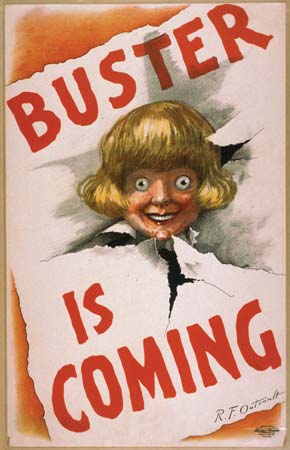
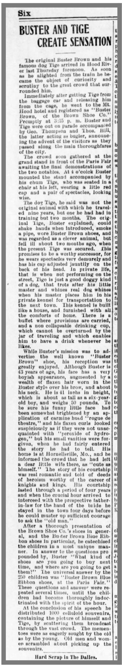
Buster Brown at Paris Fair in Hood River – Here’s an antique postcard depicting a crowd that had gathered in the street in downtown Hood River, Oregon. They’ve assembled in front of the popular clothing store Paris Fair. Paris Fair was a popular clothing store that was in business in Hood River for 80 years until it closed in 1988.
Buster Brown was a cartoon that was created in 1902 by Richard F. Outcault. The comic centered around a young boy who appeared to be conservative and well behaved but was actually a mischievous prankster and his pet dog Tige. Think of Calvin and Hobbs but with Calvin dressed in a yellow Little Lord Fauntleroy suit and Hobbs willing to bite if he felt it needed. The comic strip was very popular back then and the Brown Shoe Company saw potential in using the character as the mascot for a line of children’s shoes.
Soon after the Brown Shoe Company adopted their new mascot, signing a licensing agreement with Outcault at the 1904 St. Louis World’s Fair, they created a campaign where Buster Brown and his dog Tige would make public appearance at shoe stores around the country. They would use Little People to act the part of Buster Brown. Young and old would come to these events to see Buster Brown, and many pair of shoes were sold. It was so successful that Buster Brown shoes have been popular beyond extent of the life and popularity of the cartoon character Buster Brown and are still a popular brand of children’s shoe today.
The Paris Fair Department Store advertised and promoted the event in the Hood River Glacier Newspaper and by the look of the size of the crowd it was a successful event. You can see people, young and old, pouring out into the streets in front of Paris Fair showing, even back then, how celebrity endorsements sell shoes.
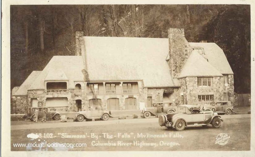
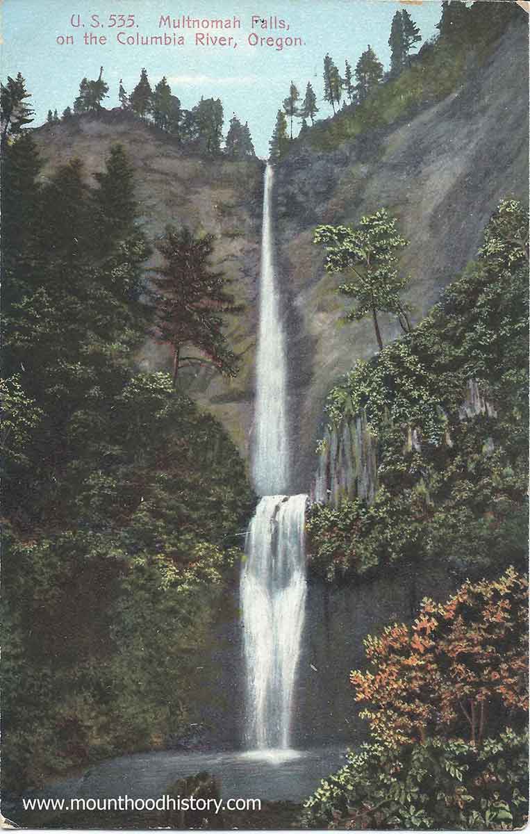
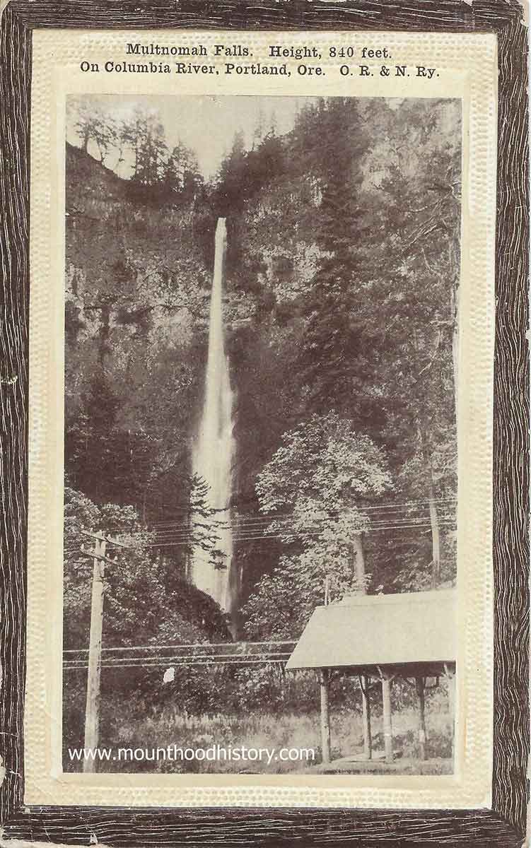
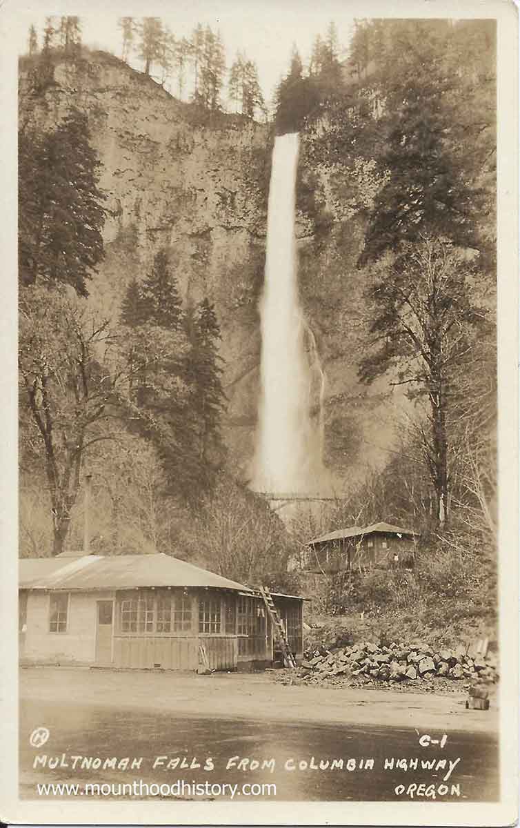
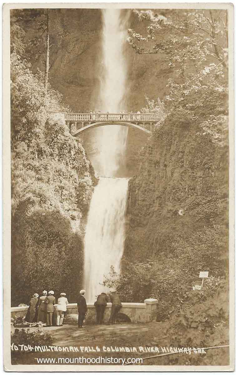
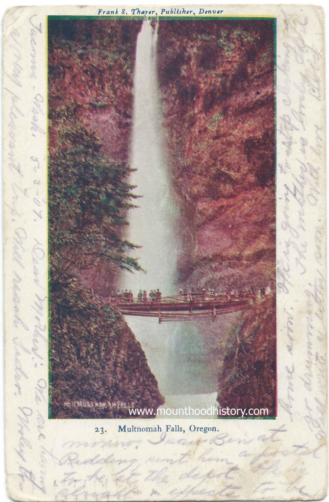
Multnomah Falls History – The Bridge Over the Falls – Multnomah Falls is a two tiered waterfall located in the scenic Columbia River Gorge just east of the city of Portland. It was formed about 15,000 years ago as a result of the cataclysmic Missoula Floods, a series of massive floods that scoured out the Columbia River Gorge. It has a total height of 620 feet, with the upper falls being 542 feet and the lower segment being 69 feet. It’s the tallest waterfall in Oregon and the second tallest year-round waterfall in the United States, fourth largest if seasonal falls are included.
Multnomah
Falls was named according to a legend of the local native Multnomah people that
tells the story of how a beautiful maiden sacrificed herself to save the tribe
from a plague by throwing herself from the top of a cliff. The tribe was saved
and a creek formed at the top of the cliff creating Multnomah Falls.
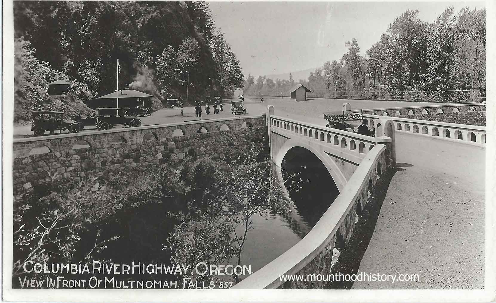
From 1884 until World War II the ORNCo Oregon Railroad and Navigation Company operated a train stop at Multnomah Falls. It was around this time that the “bow string truss” bridge across Multnomah Creek, at the same location as the present Benson Bridge, was built. Somewhere around 1891 the bridge was reinforced but by 1899 the bridge was gone, most likely decayed and washed into the creek.
In
1915 a lot was happening in the gorge. Tourism was increasing on the steam
powered sternwheelers and train excursions but would soon be replaced by
automobile traffic on the soon to be completed, and now historic, Columbia
River Highway. With this tourism comes the need for hiking trails. Many of the established
trails were being improved and new ones were being made. One in particular was
recommended by Samuel Lancaster to the Progressive Business Men’s Club of
Portland to build a trail from the base of Multnomah Falls to the top of Larch
Mountain to the south and the source of Multnomah Creek.
The club raised money and with donations from Portland businessman Simon Benson and his son Amos worked with the US Forest Service to establish the trail and a fire lookout on Larch Mountain. Simon Benson then hired Italian stonemasons to construct a bridge to allow access to the trail for visitors to the falls. The bridge is named Simon Benson Bridge in his honor.
That same year Benson donated 1,400 acres of land, including the land where Multnomah Falls is located to the city of Portland. Subsequently the ORNCo donated the land at the base of the falls, where their train station was located, to the city in agreement that a lodge would be built there the same year. The stone Multnomah Falls Lodge’s construction was commissioned that year and the lodge was completed in 1925.
The historic Columbia River Highway was completed and dedicated in 1917 allowing Portlanders to easily take a bus or drive an automobile through the gorge while stopping at it’s amazing waterfalls, especially Multnomah Falls. The Benson Bridge is still used today and provides breathtaking views of the falls up close and personal. It has become a part of Multnomah Fall’s history.
31 Jan 2013 …Multnomah Falls is located on the Oregon side of the Columbia River … I AM
mixed Native and Rainbow Child and have heard this story many …
The Filming of an Oregon Silent Movie on Mount Hood
I recently came across an intriguing series of photographs documenting the filming of an early Oregon silent movie on Mount Hood. These images capture a crew of photographers and actors reenacting a mining scene. A wooden sluice stands in the background, while men with shovels appear to be panning for gold. Another scene features armed men, seemingly defending their claim.
Dating the Film: Clues from Government Camp
One of the photos provides a key clue about the film’s timeframe. Government Camp is visible in the background, showing Dr. Kelly’s cabin and the old Timberline Climbers Cabin. This structure once stood near the future site of Timberline Lodge. Given these details, I believe the images most likely document the filming of A Nugget in the Rough, a silent movie shot on Mount Hood in 1917.
A Story of Gold Miners
The movie appears to revolve around gold miners. Several images depict men using a sluice to pan for gold on the slopes of Mount Hood. In another, the miners brandish rifles, possibly protecting their claim. After acquiring the photos, I discovered additional scenes filmed in Portland. These town scenes include log buildings, a makeshift settlement, and a saloon filled with miners spending their earnings. A group of “painted ladies” adds to the Old West atmosphere.
Preserving a Piece of Oregon’s Film History
Owning these photos has been both exciting and bittersweet. They offer a rare glimpse into early filmmaking in Oregon, possibly among the first silent films shot in the state. However, I feel disappointed that the collection was split up and separated over time. These images are historically significant, capturing the pioneering days of Oregon cinema.
The story of A Nugget in the Rough and its filming on Mount Hood deserves more recognition. Perhaps, with further research, more details about this lost piece of history can come to light.
This list of films shot in the U.S. state of Oregon are listed first by region, and then
… The first documented film made in Oregon was a short silent film titled The …
This is an old privately made Real Photo Postcard of a crew of three friends taking a break from hiking or climbing on Mount Hood.
The writing on the front reads: “Crater Rock Mt Hood – Steaming Rocks – August 22nd, 1906”. Climbing Mount Hood has always been a popular sport with tourists over the last 100 years. Although Crater Rock is not the summit of the mountain it’s a healthy hike above Timberline to get to that location.
This photo was taken in the summertime when climbing Mount Hood is the most dangerous so it’s most likely that this group didn’t make it to the top.


