Make no mistake — that map up there is the real thing
by Paul Keller
HUNCHBACK MOUNTAIN — This dispatch is being written, believe it or not, inside “The Map” — approximately North Dakota, maybe eastern Montana.
If you’re new here, “The Map” is the namesake of Map Turn — Highway 26’s answer to the masked executioner.
Map Turn is the sweeping curve located west of Government Camp — just downslope from the new truck escape ramp — where several persons have perished in auto accidents in recent years. Eleven to date, according to Hoodland Fire Chief Don Arnimroot. (Interesting footnote: since the state highway department’s safety improvements were installed recently — including the truck escape ramp, new guardrails and better signing — Map Turn has failed to injure anyone!).
All past victims, however, failed to negotiate the fatal Map Turn bend: careening off the brim, down into the teeth of Laurel Canyon. D.O.A.
Hence, Map Turn — at least prior to these highway improvements — had achieved it’s own notoriety. Sort of a lethal hall of life hero. That potential executioner waiting to send the next unfortunate motorist on to St. Peter’s Gate.
But back to the story. Why tag it “Map Turn?” What and where is this “map,” anyway?
To understand the nomenclature, apply the brakes and pull your heap over on this popular corner. Then look west, my friend, look west.
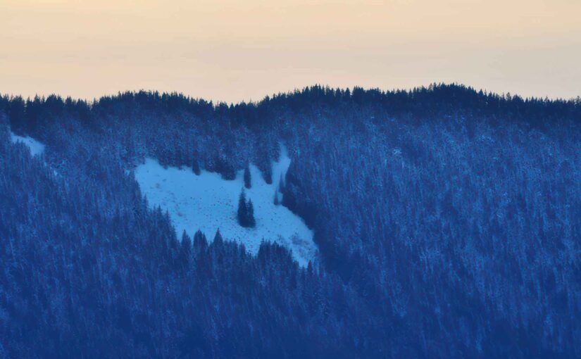
Up there (the here where I now sit) on the eastern facing backbone of distant Hunchback’s ridge, you’ll see it. How unmistakable, really. The Map.
The map of our United States that is.
An almost perfect rendition, too. Including a well defined Florida, the New England states, and — who knows how — even Alaska. Shortcomings include an omission of the Hawaiian Islands and a dwarfed Texas. (Nobody’s perfect).
Now about those long mulled tales defending this as a logged parcel of land purposely chain-sawed and tailored by man. Pure hogwash.
Take it from this hiking boot sore reporter. The Map is a natural phenomenon. A field of giant gray boulders and a few stubborn trees.
Goodness knows how this big stone pockmark ever took on the spitting image of America the Beautiful.
In fact, maybe the roadside term shouldn’t be dismissed as simply the land-mark for a well known highway turn that affords an unblemished view of it.
Perhaps this mysterious handiwork by Mom Nature — or whatever deity you prefer — might be the Mount Hood Corridor’s own sleeping version to England’s intriguing Stonehenge.
At least an appreciative cartographical society might consider somehow honoring our natural tribute to the good old U.S. of A.
Well it’s high time I trudged back down and filed this story. What? How did I get up here in the first place? That’s for you to figure out.
Try using, pardon the repetition, a map.
